

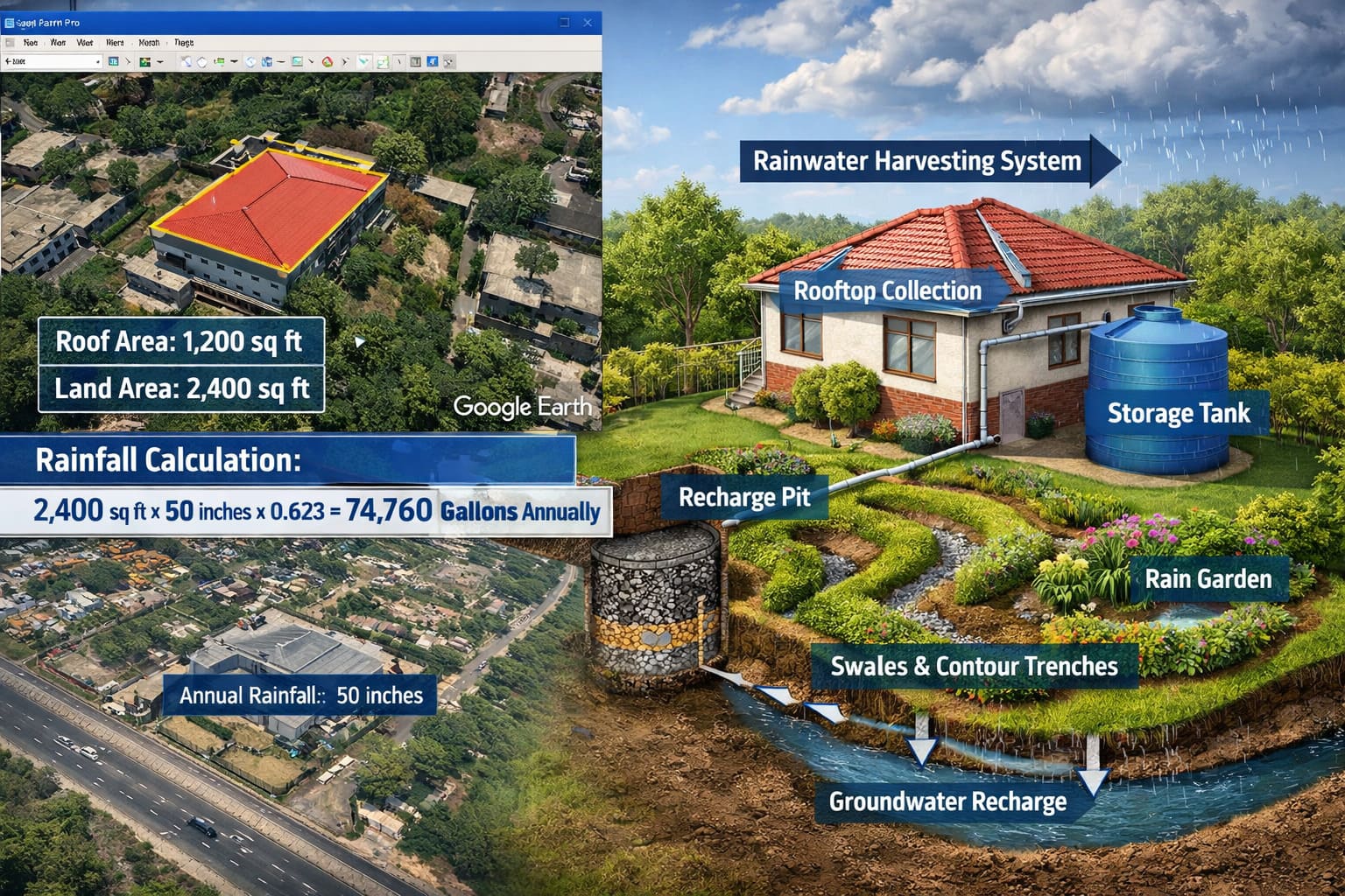
Rainwater is one of the most valuable natural resources for any property owner. Instead of letting rainwater flow away into drains, you can measure how much rain falls on your land and plan systems to store, recharge, or control it.
Using Google Earth Pro, anyone can estimate the total rainwater falling on their roof and land area. With a simple calculation and satellite measurements, property owners can design rainwater harvesting systems, recharge pits, and flood control measures.
This guide explains how to use Google Earth Pro to measure your property and estimate the amount of rainwater available annually.
Why Measuring Rainfall on Your Property Matters
Understanding how much rainwater falls on your property helps you:
- Design effective rainwater harvesting systems
- Reduce flooding during heavy rains
- Improve groundwater recharge
- Plan landscaping and irrigation
- Reduce dependence on municipal water supply
In cities like Chennai, where rainfall is seasonal but intense, proper rainwater planning can significantly improve water availability.
Step 1: Measure Your Roof or Land Area Using Google Earth Pro
Follow these steps:
- Open Google Earth Pro desktop version
- Search your address or property location
- Zoom in until your building or land boundary is clearly visible
- Click Add → Polygon
- Trace the boundary of your roof or land
- The software automatically calculates the area
You can measure:
- Roof area (for rainwater harvesting)
- Entire plot area (for runoff and flood planning)
The result can be displayed in square feet or square meters.
Step 2: Find Annual Rainfall for Your Location
To estimate rainwater availability, you need the average annual rainfall of your location.
For example:
- Chennai average rainfall: about 1200–1400 mm per year
- This equals roughly 47–55 inches annually
This rainfall value will be used in the rainwater calculation formula.
Step 3: Use the Rainwater Calculation Formula
Once you know the area and rainfall, you can calculate the total rainwater volume using this formula:
Rainwater (gallons) = Area × Annual Rainfall × 0.623
Where:
- Area = surface area in square feet
- Annual rainfall = rainfall in inches
- 0.623 = conversion factor to convert rainfall into gallons
Example Calculation
If your roof area is 1200 sq ft and annual rainfall is 50 inches:
1200 × 50 × 0.623 = 37,380 gallons of rainwater per year
In liters, this equals approximately 141,000 liters annually.
This means a typical house roof can collect more than one lakh liters of water every year.
Step 4: Estimate Rainwater Flow Across Your Entire Plot
Rainwater does not only fall on your roof. It also falls on:
- Driveways
- Gardens
- Open land
- Parking areas
By measuring your entire plot area in Google Earth, you can estimate the total rainfall volume on your property.
For example:
Plot size: 2400 sq ft
Rainwater volume:
2400 × 50 × 0.623 ≈ 74,760 gallons per year
That is roughly 2.8 lakh liters of water annually falling on the land.
Planning Rainwater Harvesting and Flood Control Systems
Once you know how much rainwater falls on your property, you can design systems to manage it efficiently.
1. Swales

A swale is a shallow trench dug along the contour of the land.
How it works
- Rainwater flows into the trench
- The trench slows down water movement
- Water gradually soaks into the soil
Think of it as a small ditch that temporarily holds rainwater, allowing the ground to absorb it instead of letting it flow away.
Swales are commonly used in:
- Landscaped gardens
- Farms
- Large residential plots
2. Recharge Pit

A recharge pit is a deep hole filled with layers of stones, gravel, and sand.
Purpose
- Rainwater enters the pit
- Water slowly percolates underground
- Groundwater levels increase
Recharge pits are widely used in urban rainwater harvesting systems, especially in Chennai where groundwater recharge is critical.
3. Contour Trenches
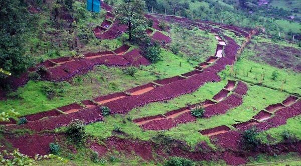
Contour trenches are long trenches dug across a sloping landscape.
Function
- They stop water from rushing downhill
- Rainwater spreads slowly across the land
- Soil absorbs water gradually
Farmers use contour trenches to:
- Reduce soil erosion
- Improve soil moisture
- Increase groundwater recharge
4. Rain Gardens

A rain garden is a landscaped depression designed to collect rainwater runoff.
How it works
- Rainwater from roofs or pavements flows into the garden
- Plants and soil absorb the water
- Water gradually infiltrates into the ground
Rain gardens help reduce:
- Flooding
- Surface runoff
- Drainage pressure
5. Storage Tanks
Rainwater can also be stored for later use.
How it works
Roof rainwater is directed through pipes into:
- Underground sumps
- Overhead storage tanks
- Rainwater harvesting tanks
Stored water can be used for:
Groundwater rechargend improving groundwater recharge.
Gardening
Cleaning
Household usage
Flood Control Benefits
By combining rainfall calculations with proper water management systems, property owners can:
- Reduce flooding during heavy rain
- Prevent soil erosion
- Increase groundwater levels
- Improve landscape sustainability
Proper planning transforms rainwater from a drainage problem into a valuable resource.nd prevent waterlogging during heavy rains.
Conclusion
With the help of Google Earth Pro, property owners can easily measure their land and roof areas to estimate how much rainwater falls on their property each year.
By combining this data with simple rainfall calculations, homeowners can design efficient systems to harvest rainwater, recharge groundwater, and prevent flooding.
In water-stressed regions like Chennai, adopting such practices can transform a property into a sustainable, water-resilient landscape.
Aquifer Zone and Flood Risk Check
Property owners can further improve water planning by using services from Verified.RealEstate.
- The Aquifer Zone Check helps determine whether a property sits above a groundwater-bearing layer, indicating its potential for effective groundwater recharge through rainwater harvesting.
- The Flood Check Service analyzes terrain, drainage patterns, and historical data to identify if the property is located in a flood-prone area. These insights help buyers and developers plan safer, more sustainable properties while managing rainwater effectively.