

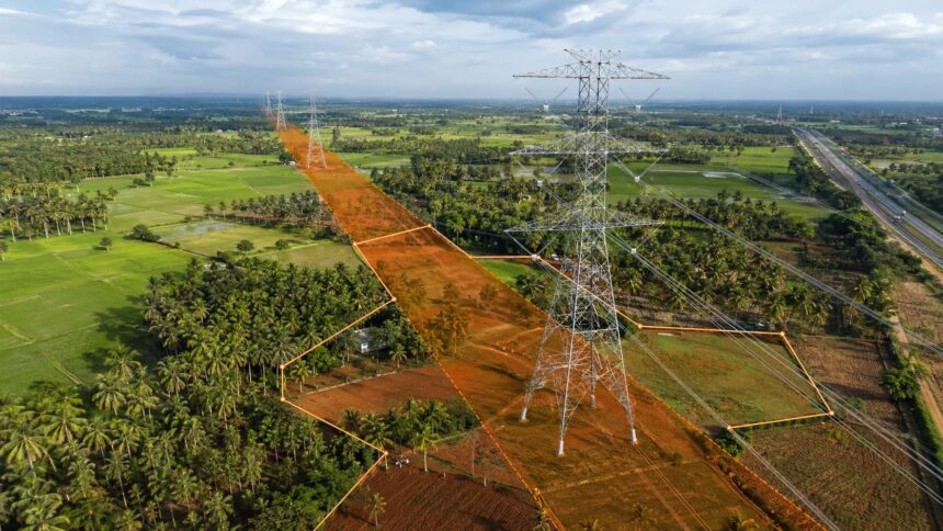
TANTRANSCO’s proposed high-voltage transmission project covering Kavathampalayam, Edayarpalayam and associated power corridors has moved to an important tender stage.
The project includes:
- a 765/400 kV substation at Kavathampalayam;
- a 400/230–110 kV substation at Edayarpalayam;
- a major 765 kV connection between Kavathampalayam and Ariyalur; and
- associated 400 kV transmission lines supplying the Coimbatore region.
The active bidding windows for both primary packages of the Kavathampalayam–Ariyalur project are closed, and the tenders are currently in the evaluation or post-opening phase
- Kavathampalayam is located on the Uthukuli–Kunnathur side of Tiruppur district.
- The proposed Edayarpalayam substation is in Sulur taluk of Coimbatore district, near Chettipalayam.
The proposed connection therefore covers the wider Tiruppur–Coimbatore belt, with farmer objections reported around Palladam, Vavipalayam and Vadamalapalayam.
The complete transmission project was earlier estimated to cost around ₹4,500 crore. No revised official project estimate has been publicly disclosed in the 2026 tender records.
Two different transmission routes are involved
The project should not be understood as one single line.
The Kavathampalayam–Ariyalur 765 kV backbone has been reported to extend for approximately 240 km. A separate 400 kV feeder is proposed between Kavathampalayam and Edayarpalayam.
Earlier project reports placed this feeder at around 47 km. Farmers opposing the proposed alignment have referred to a corridor of around 70 km. The final official route length and tower positions must therefore be confirmed through the approved alignment.
Power Grid Corporation also issued preparatory construction packages during 2026 for sections of the transmission lines and the two substations. However, these were pre-bid arrangements and do not prove that Power Grid has won TANTRANSCO’s complete project.
Farmers say agricultural land could be affected
Farmers first submitted representations against the proposed route in 2025. Their objections continued during 2026.
In April, farmers from Vavipalayam and Vadamalapalayam near Palladam said the proposed 400 kV corridor could pass through agricultural lands. They raised concerns about damage to crops and coconut trees, safety near houses, reduced land value and restrictions on future land use affecting the livelihood of more than 100 farming families.
They asked the government to consider taking the line beside roads or highways instead of through productive farmland.
However, an alternative highway alignment is not automatic. It would require highway permission, adequate space for towers, safe clearances and technical approval. Placing a long 400 kV line underground would also be considerably more expensive than an overhead line.
Will the entire property be acquired?
Usually, no.
Land required for a large substation may be purchased or acquired. Earlier reports stated that the Kavathampalayam substation required approximately 100 acres, with part of the land already secured.
Transmission-line land is treated differently. The electricity authority generally obtains a right to erect towers, carry conductors and enter the property for maintenance. The landowner may continue to own the land.
But ownership alone does not guarantee unrestricted use.
A tower base can permanently occupy part of the property. Buildings, tall trees and certain other activities may be restricted within the transmission corridor. This can affect farming, layout planning, construction potential, bank lending and resale value.
For general understanding, the Right of Way for a 765 kV line can be around 67 metres, while a 400 kV corridor can be around 46 metres. The actual width depends on the approved tower and conductor design.
What compensation may be available?
Tamil Nadu’s transmission-line compensation framework provides separate treatment for:
- the area occupied by the tower base;
- land falling within the Right of Way corridor; and
- crops and trees damaged during construction.
G.O. Ms. No.86, Energy Department, dated October 30, 2019, increased compensation to 100% of the applicable land value for the tower-base area and up to 20% for the Right of Way corridor, with crop and tree compensation calculated separately.
This does not mean the owner receives compensation for the entire survey number. The calculation normally covers only the affected tower-base and corridor portions.
The Central Government has subsequently issued higher compensation guidelines. However, this is described as an intra-state transmission project. Landowners should not assume that the Central percentages will automatically apply unless TANTRANSCO or the Tamil Nadu Government confirms the applicable policy.
For a detailed explanation of construction restrictions, compensation and landowner rights, read Verified.RealEstate’s guide: High-Tension Power Lines on Private Land: Rules, Land Value Loss and Landowner Rights. It also explains the essential checks buyers should complete before purchasing land near a high-voltage transmission corridor.
Are affected survey numbers available?
No verified survey-number schedule has been publicly released so far.
The available records reveal the substations, broad transmission connections and some villages mentioned by farmers. They do not provide a complete list containing:
- survey numbers and subdivisions;
- tower coordinates;
- tower-base locations;
- the conductor centreline; or
- the exact Right of Way passing through each property.
Therefore, land should not be declared affected merely because it is situated near Kavathampalayam, Edayarpalayam, Vavipalayam, Vadamalapalayam or Palladam.
What should owners and buyers check?
Before purchasing land near the proposed corridor, buyers should verify the exact survey number, subdivision, FMB boundaries and any electricity-department markings or notices.
Owners should also preserve copies of their patta, FMB sketch, sale deed, crop details and photographs of existing trees and structures. These records may become important if a tower is proposed or compensation has to be calculated.
Once the official tower alignment is available, the land owners can use Verified.RealEstate survey and FMB mapping to check whether a parcel falls inside, partly inside or outside the affected strip.
The HT Line Proximity Check helps identify nearby high-tension lines and substations. Use it for an early warning, then confirm the result with official utility records and the final approved alignment.
The present position
The power project has advanced to technical tender evaluation, and farmer objections remain unresolved in the public domain. But the developer, final tower alignment and affected survey numbers have not yet been officially announced.
For landowners, the next critical developments will be the contract award, route survey, tower-spotting work and individual land notices.
Disclaimer: This article provides general information based on publicly available tender records and news reports. It does not confirm that any individual property is affected. Owners and buyers must verify the approved alignment and survey-level records with TANTRANSCO and the concerned authorities.