


Tagline: Trichy Corporation will digitally map properties across all five zones to identify additional floors, larger built-up areas and differences in municipal tax records.
Tiruchirappalli City Corporation is preparing to conduct its first comprehensive citywide LiDAR-GIS survey. Approximately 2.4 lakh property-tax assessments across the Corporation’s five zones will be digitally mapped and compared with municipal records.
The four-month project is estimated to cost around ₹1.6 crore. A tender has been floated to select the agency that will conduct the survey.
Which Areas Will Be Covered?
The survey will cover all five zones of Tiruchirappalli City Corporation:
- Zone 1 – Srirangam
- Zone 2 – Ariyamangalam
- Zone 3 – Tiruverumbur
- Zone 4 – Ponmalai
- Zone 5 – K. Abishekapuram
Properties situated outside the present Corporation limits are not included merely because they form part of the wider Trichy urban area.
What Will the LiDAR Survey Check?
Survey-grade drones will use LiDAR, DGPS and multi-oblique cameras to capture buildings from different directions. The system will create accurate 2D and 3D property maps.
The Corporation intends to identify:
- Built-up areas recorded below their actual size
- Unauthorised additional floors
- Structures constructed on terraces
- Floor-wise area differences
- Changes in property use
- Other discrepancies affecting property-tax assessment
A building shown as smaller in the municipal record than its actual size could be considered for reassessment after officials verify the survey findings.
Will Every Property-Tax Bill Increase?
No. The survey does not mean that all 2.4 lakh property owners will automatically receive higher tax demands.
The tender is currently for mapping and data creation. Revised assessments may follow only where the Corporation finds differences between the actual building and the existing tax record.
No separate order has yet been published explaining when revised demands will begin, how differences will be calculated or what objection procedure will apply to LiDAR-based corrections.
Tender Confirms a 120-Day Survey
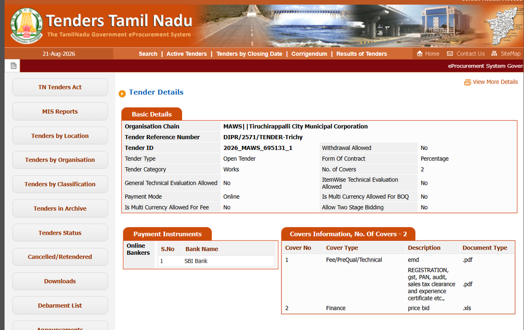
The official tender carries the identification number 2026_MAWS_695131_1 and reference number DIPR/2571/TENDER-Trichy.
It specifies:
- Coverage of all five Corporation zones
- LiDAR and DGPS-based mapping
- Four angled camera views and one downward-facing view
- Creation of 2D and 3D maps
- A work period of 120 days
- Bid-closing date of September 8, 2026
The survey agency must first be selected before citywide mapping can begin.
Part of Trichy Corporation’s Revenue Plan
The LiDAR project follows Trichy Corporation’s March 2026 announcement that it would check whether property tax—particularly on commercial buildings—was being assessed correctly.
The Corporation was then facing a budget deficit of more than ₹100 crore. Property tax contributed ₹176.6 crore, representing around 29% of its internally generated revenue.
The new digital survey appears to be the next step in that plan, allowing the Corporation to check a much larger number of properties using consistent measurements.
Survey Data Will Also Support City Planning
The project will create a city database containing around 78 types of information. It will map roads, road widths, parks, streetlights, hospitals, police stations, fire stations, public utilities and green cover.
Corporation Commissioner Veer Pratap Singh said the information would support urban planning and be integrated with the Corporation’s e-governance systems.
This appears to be part of a wider Tamil Nadu rollout
Similar LiDAR–drone mapping tenders have recently appeared for Madurai, Tirunelveli, Thoothukudi, Vellore, Erode, Karur, Namakkal, Avadi and other urban local bodies.
Therefore, this appears to be a coordinated urban-mapping programme across Tamil Nadu—not an isolated Trichy project.
What Should Trichy Property Owners Check?
Owners should compare:
- The building’s actual built-up area
- The sanctioned building plan
- The number of approved floors
- The usage recorded as residential or commercial
- The area mentioned in the municipal property-tax assessment
These records will become important if a future reassessment contains an incorrect measurement or property classification.
Local Property Verification Support in Trichy
Verified.RealEstate also provides property verification and due-diligence support in Tiruchirappalli, including industrial land, warehouses and commercial buildings. With the LiDAR survey expected to compare actual structures against municipal records, VRE can help owners examine building approvals, property measurements, land records and permitted usage to identify possible differences before committing to a property or responding to a future tax reassessment.