

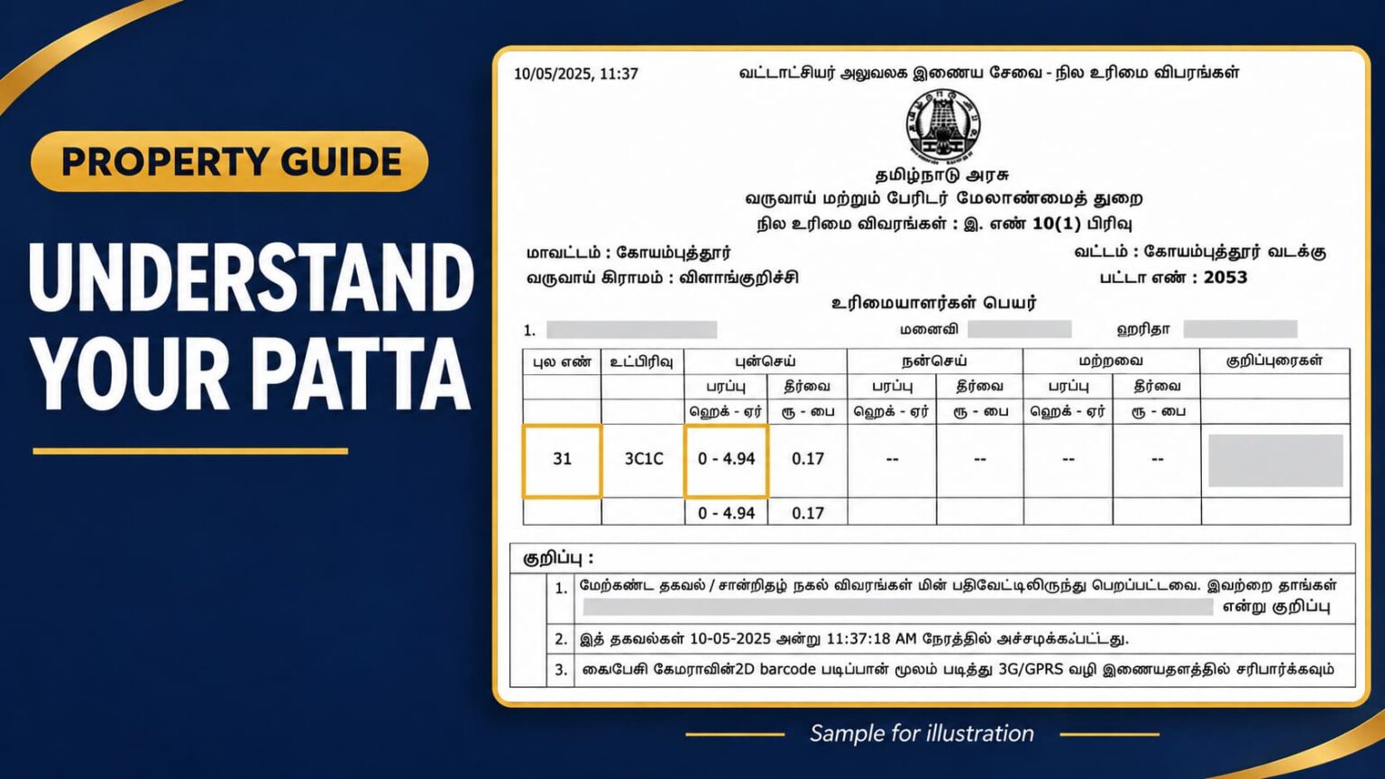
A patta (பட்டா) is a land revenue record that shows the recorded holder’s name, survey number, land classification and area. It is an important supporting document when checking property details for a purchase, inheritance or name transfer. However, a patta alone does not conclusively prove ownership.
You can view and download available patta/chitta records through the Tamil Nadu government’s land-records portal. An authorised e-Sevai centre (இ-சேவை மையம்) can help you access online services. For revenue-record enquiries, approach the Taluk/Tahsildar office (வட்டாட்சியர் அலுவலகம்). The Village Administrative Officer—VAO (கிராம நிர்வாக அலுவலர்) can help clarify local land-record details.
👉You can also use Verified.RealEstate’s Patta/Chitta tool to access available records using the property’s location and patta number or survey details.
👉If you want to apply for a patta, the Patta Assistance service offers support with documents, the application and follow-up with the relevant revenue office.
Keep your patta beside you as you read this guide. Follow each heading and compare it with your document to understand what the Tamil terms, numbers and measurements mean. This guide explains the common rural patta/chitta format. Natham and urban TSLR records may have a different layout.
மாவட்டம், வட்டம், கிராமம்: Start with the location
The top section identifies where the land is recorded.
| Tamil term | Meaning | What to check |
|---|---|---|
| மாவட்டம் | District | The district where the land is located |
| வட்டம் | Taluk | The revenue taluk covering the land |
| வருவாய் கிராமம் / கிராமம் | Revenue village | The village under which the land is recorded |
Compare these entries with the sale deed. The revenue village name may differ from the locality name used in the postal address.
பட்டா எண்: Understand the patta number
பட்டா எண் is the patta account number in the revenue records.
For example, பட்டா எண்: 2053 means the record belongs to patta account 2053 in that revenue village.
The patta number is different from the survey number. One patta can contain several survey numbers or subdivisions. Always read it together with the district, taluk and village.
உரிமையாளர்கள் பெயர்: Check the recorded holders
This section lists the people recorded as holders of the land. Check the names, initials and relationship details carefully.
A father’s or husband’s name may appear to identify a holder. For example, “ரவி, தந்தை: குமார்” means Ravi, whose father is Kumar. Kumar does not become a joint holder simply because his name appears as Ravi’s father.
If several people are separately listed as holders, it may be a joint patta. Do not assume that everyone has an equal share. Check the sale deed, partition deed or other relevant title document to understand each person’s share.
A patta also does not automatically list every family member or legal heir. After a holder’s death, the record may continue to show that person’s name until it is updated.
புல எண் and உட்பிரிவு: Identify the land parcel
புல எண் / சர்வே எண் means survey number. உட்பிரிவு எண் means subdivision number.
| Field | Example |
|---|---|
| புல எண் — Survey number | 31 |
| உட்பிரிவு — Subdivision | 3C1C |
Read these together as Survey No. 31/3C1C.
Every letter and number matters. For example, 31/3C1C and 31/3C1D identify different subdivisions, even though the main survey number is the same.
Compare the complete reference with the sale deed and the relevant survey sketch.
புன்செய், நன்செய், மற்றவை: Read the land classification
The table commonly has separate sections for different land classifications.
| Tamil term | Meaning |
|---|---|
| புன்செய் — Punjai | Dry agricultural land |
| நன்செய் — Nanjai | Wet agricultural land |
| மற்றவை | Other category; check the detailed revenue classification |
For Punjai land, the area and assessment generally appear under the புன்செய் columns. For Nanjai land, they appear under நன்செய்.
If a patta includes parcels of both classifications, entries can appear in both sections against the respective rows. This does not automatically mean the same parcel is classified as both Punjai and Nanjai.
Punjai does not by itself mean an approved residential plot. Planning land use and layout approval require separate checks.
பரப்பு: Read the recorded land area
பரப்பு means the land area recorded for the survey number or subdivision in that row.
Check the measurement unit before reading the number. A common heading is ஹெக்–ஏர், meaning hectares–ares.
For example, an entry of 0–4.94 means:
0 hectares + 4.94 ares = 494 square metres.
It does not mean 4.94 acres or 4.94 cents.
If several rows are listed, read each row separately. A total at the bottom, if provided, adds the listed areas. In a joint patta, that total does not automatically represent one person’s individual share.
How to convert ares into cents
Use this formula:
Area in cents = Area in ares × 2.471
For example:
4.94 ares × 2.471 ≈ 12.21 cents.
| Entry under ஹெக்–ஏர் | Meaning | Approximate area in cents |
|---|---|---|
| 0–4.94 | 4.94 ares | 12.21 |
| 0–5.00 | 5 ares | 12.36 |
| 0–10.00 | 10 ares | 24.71 |
| 1–5.00 | 1 hectare + 5 ares = 105 ares | 259.46 |
Remember: 1 hectare = 100 ares, and 1 are = 100 square metres.
If the hectare part is more than zero, convert it into ares first. Then add the remaining ares and multiply by 2.471.
தீர்வை: Understand the revenue assessment
தீர்வை is the recorded land revenue assessment. The heading ரூ–பை refers to rupees and paise.
For example, 0.17 under this heading means 17 paise.
This amount is not the property’s sale price, market value or guideline value. The entry also does not by itself confirm whether the amount has been paid.
குறிப்புரைகள்: Read the remarks
The குறிப்புரைகள் section may contain references to revenue proceedings, record changes or orders.
Do not skip an entry because it looks like a long reference number. If its meaning is unclear, seek clarification from the relevant revenue office.
Also check the digital signature details, verification reference and print date. The print date shows when the copy was generated. It is not necessarily the date the property was bought or the patta was changed.
Compare the patta with other property documents
Understanding the fields is the first step. The next step is checking whether the details agree with the other records.
| Document | What to compare |
|---|---|
| Sale deed | Names, village, survey number, subdivision and area |
| அ-பதிவேடு — A-register | Detailed revenue classification and related entries |
| புலப்படம் — FMB sketch | Recorded parcel shape and survey measurements |
| வில்லங்கச் சான்று — EC | Registered transaction and encumbrance entries |
If names, survey numbers or areas differ, find out why before relying on the documents for a transaction. A difference may need an explanation, an updated record or a formal correction.
A patta helps you understand how the land is recorded by the Revenue Department. It should be read together with the title documents and other relevant records to assess ownership and the property’s status.