



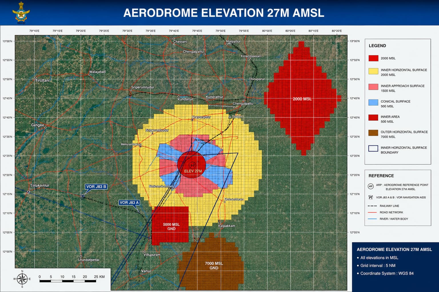
The Invisible Ceiling Over Real Estate
In modern urban real estate, a plot’s development potential is determined not only by municipal floor space index (FSI) or local land-use zoning, but also by an invisible 3D airspace grid surrounding civil and military airports. Known as Color-Coded Zoning Maps (CCZM), these regulatory grids dictate the maximum height to which any structure—residential towers, commercial complexes, industrial chimneys, or telecom towers—can be constructed.
Overseen by the Airports Authority of India (AAI) under the Ministry of Civil Aviation, CCZM guidelines protect aircraft navigation, instrument landing approaches, and radar coverage. For real estate developers, investors, and home buyers, failing to understand these restrictions can lead to severe project delays, unutilized building rights, or court-mandated structure demolitions.
Understanding CCZM: The Color-Coded Grid System
The CCZM is an interactive, GIS-based zoning system covering a 20 km radius around an aerodrome. The airspace is partitioned into georeferenced grid squares (typically 1 minute by 1 minute latitude/longitude). Each grid specifies a Permissible Top Elevation (PTE) measured in meters Above Mean Sea Level (AMSL).
| Zone / Color | Restriction Severity | Approval Mechanism | Real Estate Implications |
| 🟥RED ZONE | Critical / Maximum | Mandatory prior technical evaluation & NOC from AAI via NOCAS. Local body cannot approve directly. | High-rise construction restricted. Strict caps on height (often 15m–30m AGL). |
| 🟧ORANGE / PINK | Moderate Height Limits | Direct local body approval if building height stays below CCZM grid limit; AAI NOC required if exceeding limit. | Mid-rise developments feasible. Developers must verify exact site elevation before planning. |
| 🟨YELLOW ZONE | Low to Moderate Limits | Direct local clearance up to specified grid PTE. Exceeding requires AAI NOCAS filing. | Good vertical growth potential, subject to standard airport approach funnel margins. |
| 🟩GREEN ZONE | Peripheral / Clear | Cleared for heights up to maximum local municipal bylaws (e.g., 150m AMSL) without AAI NOC. | Unrestricted by airport OLS; standard urban planning FSI applies fully. |
Obstacle Limitation Surfaces (OLS): Key Restrictive Zones
Aviation safety relies on defining protected airspace volumes surrounding runways, known as Obstacle Limitation Surfaces (OLS):
| Surface / Zone | Distance from Airport | Restriction Level | Why Restriction Exists |
| Runway Strip / No-Build Zone | 0 – 500 meters | 100% No-Build Area | Essential safety buffer surrounding the active runway. |
| Approach & Takeoff Funnel | Aligned with runway ends (3–6 km) | Extremely Severe | Direct path where landing planes descend and taking-off planes gain altitude. |
| Inner Horizontal Surface (IHS) | Up to 4 km from airport reference point | Strict Floor Cap (e.g., ~45m AGL) | Circling area for aircraft preparing to land. |
| Conical Surface | 4 – 8 km from airport | Gradual Slope (1m height increase per 20m distance) | Transmit boundary surrounding the inner horizontal zone. |
| Defense / IAF Overlap Zones | Adjacent to military airbases | Strict Security Clearances | Requires defense security clearance in addition to civil aviation NOC. |
AMSL vs AGL: The Height Formula Every Developer Must Know
A common pitfall in real estate development near airports is confusing 1Above Ground Level (AGL) with 2Above Mean Sea Level (AMSL).
Permissible Building Height (AGL) = Permissible Top Elevation (AMSL) – Site Ground Elevation (AMSL)
If a plot is situated on elevated ground or a hill, the permissible building height above the ground drops proportionally. Accurate topographical surveys recording WGS-84 coordinates (the global GPS standard defining exact latitude/longitude in degrees) and precise site ground elevation are required for all AAI NOC applications.
Step-by-Step AAI NOC Approval Process (NOCAS)
- Topographical Site Survey: Engage a certified surveyor to record WGS-84 coordinates and ground elevation (AMSL) using differential GPS (DGPS).
- NOCAS Portal Registration: Apply online through the official AAI NOCAS portal (
nocas2.aai.aero). - Structure Data Entry: Input total height including all rooftop structures (water tanks, lift motor rooms, telecom towers, lightning arresters, and temporary construction cranes).
- Aeronautical & Radar Evaluation: AAI engineers evaluate the proposal against instrument flight rules (IFR) and communication, navigation, and surveillance (CNS) radar signals.
- NOC Issuance: AAI grants an official NOC specifying the exact maximum allowable top elevation.
Impact on Real Estate in Surrounding Areas
Floor Space Index (FSI) / FAR Underutilization
In urban hubs near airports, city zoning rules might legally grant an FSI of 3.0 to 4.0 (allowing 15–20 floors). However, an AAI height limit of 15–25 meters compresses the building to just 4–5 floors. Developers cannot utilize full sanctioned FSI unless they spread out horizontally over larger land parcels.
Land Valuation Disparities
- Funnel Zone Penalty: Land located directly under approach funnels often sees a 15% to 35% valuation discount compared to plots just a few kilometers away outside the funnel, due to limited construction potential.
- Shift to Low-Rise / Commercial: Developers pivot away from high-rise residential towers toward warehousing, logistics parks, sprawling low-rise commercial plazas, or industrial parks which don’t require tall structures.
Delays & Legal Risk for Homebuyers
- Demolition Risk: Projects built in violation of AAI height limits risk losing their Occupancy Certificate (OC) or facing court-ordered floor demolitions.
- Cost Overruns: Miscalculating ground elevation (AMSL) during initial design can stall projects mid-construction, tying up developer capital and homebuyer funds.
Positive Urban Infrastructure Impact
- Gentrification & Connectivity: Despite height caps, airport zones benefit heavily from transit infrastructure (expressways, metro lines, aviation jobs). Premium low-density boutique apartments and luxury villas often thrive in these areas due to proximity to the airport.
Note for investors : If planning to buy properties nearby the airport and Indian Air Force & Naval Air Stations, always do the land verification to identify in which CCZM the land falls under.
Find out which Tamil Nadu city neighborhoods are impacted by strict CCZM airport and airbase radar zones—read the full article here: https://community.verified.realestate/article/tamil-nadu-airport-iaf-zoning-guide-high-impact-corridors-defense-noc-rules/