

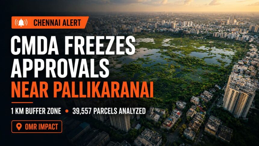
CMDA has frozen ALL building approvals within 1 km of Pallikaranai marshland. We analyzed 39,557 land parcels. Here’s what we found.
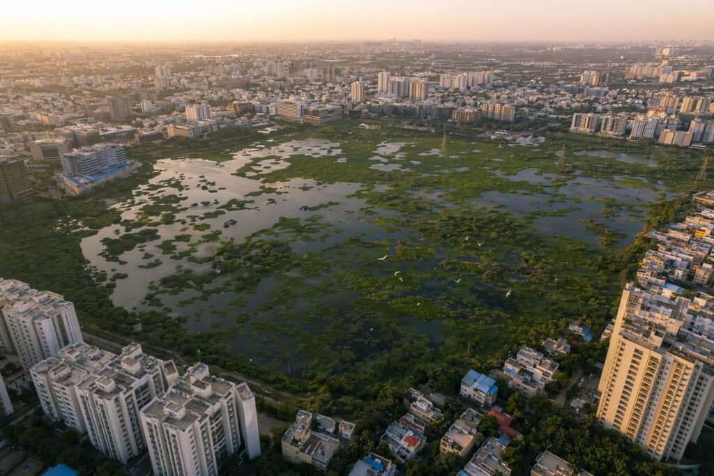
If you own or are buying property in Velachery, Medavakkam, Sholinganallur, Perungudi, Thoraipakkam, Karapakkam, Navalur, Semmancheri, Perumbakkam, Pallikaranai, Madipakkam, Siruseri, Kelambakkam, or anywhere along OMR — this article is for you.
Chennai’s most popular residential corridor sits next to India’s most contested wetland. And the government just pulled the emergency brake.
On October 9, 2025, CMDA issued Office Order No. 07/2025 — officially banning ALL new building approvals within the Pallikaranai Ramsar site and a 1-kilometre buffer zone around it.
We analyzed 39,557 land parcels across this zone. 57,480 buildings already sit inside it. Nearly 20,000 of those are residential.
Read till the end — we’ll show you exactly how to check if YOUR property is affected, and the 5 questions you must ask before signing anything.
1. What Is Pallikaranai Marshland?
Pallikaranai Marshland is Chennai’s last surviving natural wetland — and one of the few remaining urban wetlands in all of South India. Over 90% of this wetland has been destroyed — swallowed by the same IT parks, gated communities, and residential layouts that now define the “OMR corridor.”
| Period | Area | What Happened |
| 1906 | ~8,000 hectares | Original extent — ECR to Madhya Kailash |
| 1965 | ~5,500 hectares | Still largely intact |
| 1990s | ~2,450 hectares | 70% of original size remaining |
| 2002 | ~593 hectares | IT corridors, residential colonies, garbage dumps |
| 2022 | 1,247 hectares | Ramsar designation (includes reserve forest) |
| Today | ~500-660 hectares | 90%+ of original marshland destroyed |
On July 26, 2022, the Ministry of Environment declared what remains of Pallikaranai as a Ramsar Site — a Wetland of International Importance under the Ramsar Convention (1971), which India ratified in 1982. This wasn’t just a conservation gesture. It was a legal trigger that changed the rules for every property within 1 km of its boundary.
2. The NGT Hammer — CMDA Approval Freeze
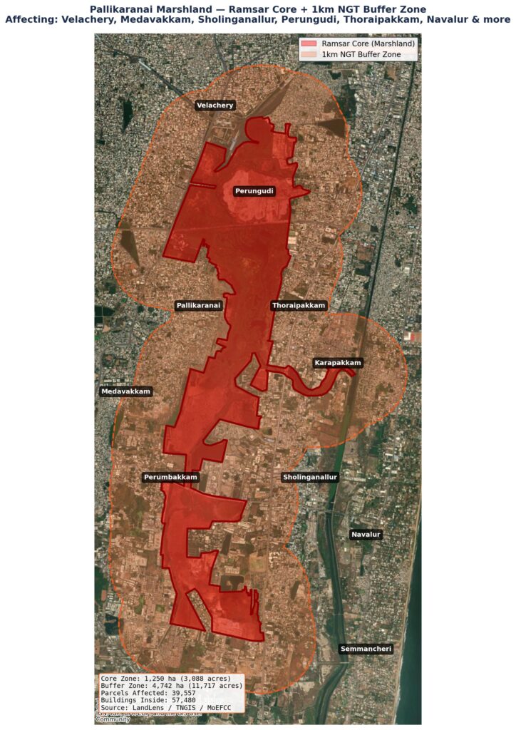
On September 24, 2025, the National Green Tribunal (Southern Bench, Chennai) issued an order that sent shockwaves through South Chennai’s real estate market.
Case: O.A. No. 91 of 2023 (SZ) — Suo Motu | Bench: Justice Pushpa Sathyanarayana (JM) + Dr. Prashant Gargava (EM) | Origin: A June 2023 news report in The New Indian Express revealed a private developer laying a road inside the Perumbakkam marshland by dumping construction debris.
The NGT ordered: “No planning permission or building plan approval shall be granted in or around the Pallikaranai Marshland Ramsar site and its zone of influence until the Tamil Nadu State Wetland Authority (TNSWA) completes scientific delineation and an Integrated Management Plan.”
CMDA responded with Office Order No. 07/2025 (October 9, 2025) — directing ALL local bodies and planning units to stop processing or sanctioning any development within the Ramsar site boundary and a 1-kilometre influence zone around it.
The CMDA order explicitly names 15 revenue villages where approvals are FROZEN: Velachery, Perungudi, Perumbakkam, Pallikaranai, Sholinganallur, Okkiyam Thoraipakkam, Karapakkam, Semmancheri, Madipakkam, Jalladianpet, Puzhuthivakkam, Kulathur, Arasankalani, Seevaram, and Injambakkam.
What “frozen” means in practice: No new planning permissions. No new building plan approvals. No new layout approvals. Existing approvals cannot justify new ones (NGT explicitly stated this). The freeze continues until TNSWA completes its scientific delineation — no timeline given.
3. The Data — 39,557 Parcels, 57,480 Buildings
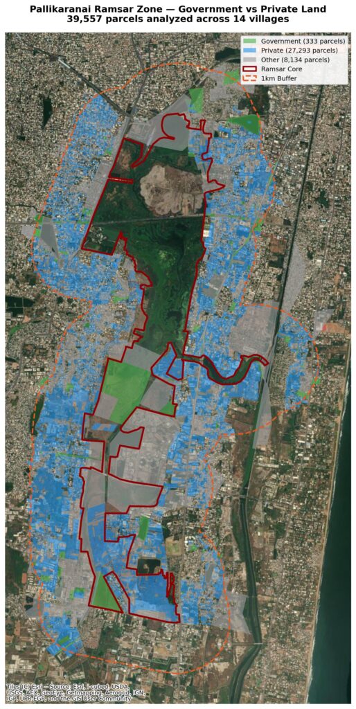
We ran a spatial analysis of every FMB-level land parcel that falls within the CMDA-frozen zone (Ramsar core + 1km buffer). Here’s what the data shows.
| Zone | Area (ha) | Area (acres) | |
| Ramsar Core (Marshland) | 1,250 ha | 3,088 acres | |
| 1km Buffer Zone | 3,492 ha | 8,629 acres | |
| Total Restricted Area | 4,742 ha | 11,717 acres | |
| Metric | Count | ||
| Total parcels in restricted zone | 39,557 | ||
| Parcels in Ramsar core | 1,728 | ||
| Parcels in buffer zone only | 37,829 | ||
| Buildings inside restricted zone | 57,480 | ||
| Residential buildings | 19,693 | ||
| Government-owned parcels | 349 | ||
| Private-owned parcels | 30,397 | ||
Let that sink in: 57,480 buildings — including nearly 20,000 residential structures — already exist inside the zone where CMDA has frozen all new approvals.
Village-by-Village Impact
| Village | Total Parcels | Govt | Private |
| Perumbakkam | 10,939 | 95 | 8,485 |
| Velachery | 6,792 | 90 | 5,545 |
| Navalur | 4,443 | 42 | 3,197 |
| Okkiyam Thoraipakkam | 3,436 | 15 | 2,143 |
| Sholinganallur | 2,462 | 16 | 1,975 |
| Karapakkam | 2,293 | 4 | 1,874 |
| Pallikaranai | 1,986 | 23 | 1,430 |
| Perungudi | 1,780 | 20 | 1,316 |
| Medavakkam | 701 | 7 | 520 |
| Semmancheri | 141 | 4 | 93 |
Perumbakkam alone has nearly 11,000 parcels in the restricted zone — more than the entire ECR corridor’s restricted count.
Source: LandLens spatial analysis of government FMB data, Supabase PostGIS
4. The Land Use Conflict — Master Plan vs Ramsar
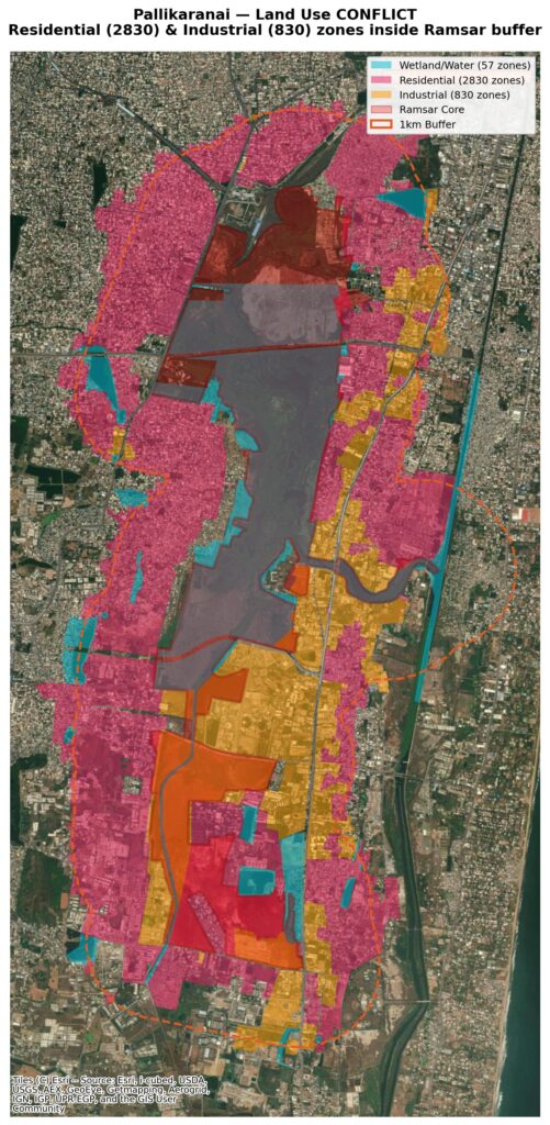
Here’s the fundamental absurdity: the existing Chennai Master Plan zones large parts of the Ramsar buffer as residential, industrial, and commercial — while Ramsar designation and NGT orders say you can’t build there.
Land Use Zones INSIDE the Ramsar Buffer:
| Master Plan Zoning | Number of Zones |
| Primary Residential | 1,740 |
| Mixed Residential | 1,138 |
| Industrial | 835 |
| Road/Transportation | 431 |
| Institutional | 191 |
| Restricted Development Zone (ARA) | 170 |
| Commercial | 53 |
| Agricultural | 53 |
| Water Body | 47 |
| Pallikaranai Swamp Area | 11 |
2,878 residential zones and 835 industrial zones sit inside the Ramsar buffer where CMDA has now frozen approvals.
The master plan says “build.” The NGT says “stop.” Your broker shows you the master plan. Nobody shows you the NGT order.
This is not a future risk — it’s a present-day regulatory collision.
CMDA is currently preparing the Third Master Plan. They’ve stated they’re awaiting precise survey data from TNSWA to integrate Ramsar boundaries into it. Until then, the freeze stands.
Source: LandLens analysis of Chennai Existing Master Plan; CMDA Third Master Plan process
5. The Shrinking Marshland — How 90% Was Destroyed
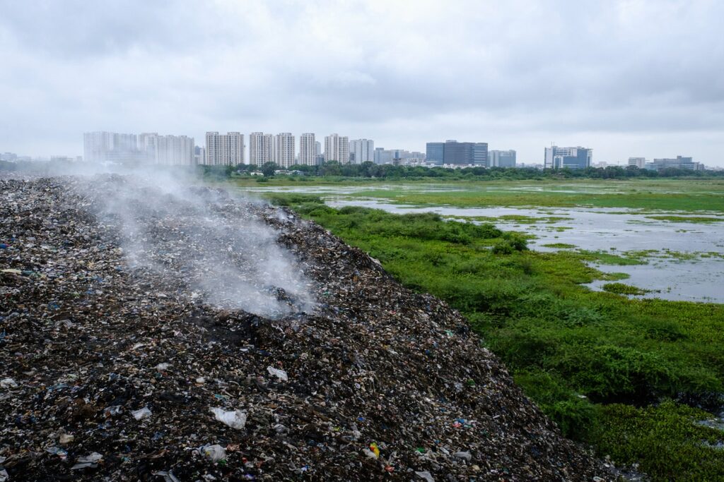
The bitter irony of the Pallikaranai situation: the same agencies that destroyed the wetland are now enforcing restrictions because of what’s left.
Timeline of Destruction:
| Year | Event | Area Lost |
| 1970 | GCC starts garbage dumping at Perungudi (19 acres) | — |
| 1980s | IT Corridor development begins along OMR | ~1,000 ha |
| 1990s | Residential colonies: Velachery, Perungudi, Medavakkam, Thoraipakkam | ~2,000 ha |
| 2002 | Dumpyard expands to 56 ha. ELCOT IT Park built on marshland | ~700 ha |
| 2007 | Dumpyard expands to 136 ha. 327 ha declared Reserve Forest | — |
| 2015 | Chennai floods — Velachery worst hit due to marsh destruction | — |
| 2022 | Ramsar designation — 1,247 ha protected | — |
| 2025 | NGT freezes approvals within 1km buffer | — |
Who Destroyed the Marshland?
A differential GPS survey found that 38% of the remaining Pallikaranai marsh is legally and illegally occupied by public and private institutions:
| Occupier | Area (ha) |
| Greater Chennai Corporation (Garbage dump) | 173.56 ha |
| ELCOT (Electronics Corporation of TN) | 163.25 ha |
| Indian Railways | 46.92 ha |
| Private encroachments | Hundreds of hectares |
The Perungudi Garbage Mountain:
• 225 acres (91 ha) — one of Asia’s largest open dump yards
• 2,300–2,700 tonnes of garbage dumped DAILY
• 4 hectares of marshland eaten every year by expanding garbage
• Air samples found 27 chemicals, 15 exceeding health standards
• 3 confirmed carcinogens found at levels up to 34,000 times above safe limits
The people who bought “premium OMR apartments” are living next to a garbage mountain that’s poisoning the air and a wetland that’s now legally protected. Neither fact appears in any broker’s pitch.
Sources: Wikipedia: Pallikaranai Marsh; Citizen Matters: “Pallikaranai at a crossroads”; Citizen Matters: “How Perungudi dump yard has made life difficult”; CAG: “Destruction of marshlands due to garbage dumping”
6. The Flood Factor — Chennai 2015
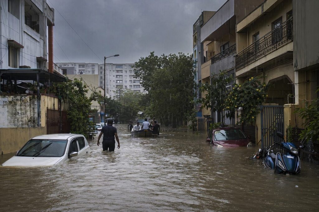
In December 2015, Chennai experienced its worst floods in over a century. Velachery was the worst-hit residential area in the entire city.
Why? Because the natural flood sponge next door — Pallikaranai Marshland — had been reduced to a tenth of its size.
The Connection:
• Pallikaranai acted as Chennai’s natural drainage basin for centuries
• Wetlands absorb monsoon rainwater and release it slowly — preventing sudden flooding
• 90% of this absorption capacity was destroyed by the same development that now defines OMR
• A Parliamentary Standing Committee report confirmed: encroachment of lakes and riverbeds was a critical factor behind the 2015 floods
Our PostGIS analysis found 11 flood inundation zones overlapping with the Ramsar buffer area. These are areas with documented flooding history.
The message is simple: the same areas where you’re buying “premium” properties are the areas that flood — BECAUSE the wetland that should have protected them was destroyed to build those very properties.
“It would be wise and economically sensible to use the marshland as a natural flood-control option.” — Madras High Court, March 25, 2008
The court said this in 2008. The city ignored it. The floods came in 2015. The NGT intervened in 2025.
Sources: Citizen Matters: “Chennai wetlands key to flood mitigation”; Scroll.in: “Preserving wetlands is crucial for Chennai to stay above water”; Mongabay: “Chennai’s fight to preserve its wetlands”
7. The Brigade Morgan Heights Case — A ₹2,000 Crore Warning
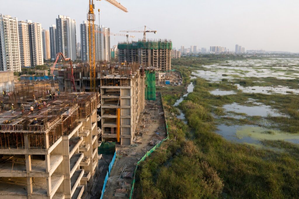
If you think the approval freeze is theoretical, consider what happened to one of Chennai’s biggest ongoing projects.
Brigade Morgan Heights — Perumbakkam:
| Detail | Information |
| Developer | Brigade Enterprises Limited |
| Location | Perumbakkam (Survey Nos. 453, 495/2c, 496, 497, 498) |
| Project Value | ₹2,000 crore |
| Units | 1,250 luxury residential units |
| SEIAA Environmental Clearance | January 20, 2025 |
| CMDA Planning Permission | January 23, 2025 (3 days later) |
| Madras HC Stay Order | October 31, 2025 |
What Went Wrong?
1. Survey parcels fall within Ramsar-notified boundaries despite environmental sensitivity
2. Arappor Iyakkam (anti-corruption NGO) alleged Brigade failed to disclose in their application that the land is a designated Ramsar site
3. The company allegedly stated the project is 1.28 km from the wetlands — when it actually adjoins the marshland
4. EC was granted by SEIAA on Jan 20, CMDA gave planning permission just 3 days later — a timeline described as “hasty and suspicious”
5. Arappor submitted a 213-page annexure to the Chief Minister, Chief Secretary, and DVAC alleging collusion
6. Casagrand Builder and Grande City Development Company were also named as respondents in the NGT case
The Madras High Court on October 31, 2025 restrained Brigade Enterprises from proceeding with construction. Construction is currently stayed. Buyers of this project face execution risk regardless of what the developer promises.
If a ₹2,000 crore project by one of India’s largest listed developers can be stayed by the High Court, what protection does your individual plot or small builder project have? The answer is: none. The Ramsar designation supersedes master plan zoning, developer approvals, and broker promises.
Sources: The Federal: “Madras HC halts luxury housing project near Pallikaranai Ramsar wetland”; The Realty Today: “Chennai Housing Project Allegedly Encroaches Pallikaranai Ramsar Wetland”; Land Conflict Watch; Verified.RealEstate Community
8. 304 Survey Numbers Identified Inside Ramsar
The Tamil Nadu State Wetland Authority (TNSWA) has identified 304 specific survey and subdivision numbers that fall within the Pallikaranai Ramsar Site, spread across 7 revenue villages:
1. Perumbakkam
2. Sholinganallur-1
3. Pallikaranai
4. Perungudi
5. Jalladianpet
6. Injambakkam
7. Okkiyam Thoraipakkam
These are not approximate zones. These are specific government survey numbers where construction is explicitly prohibited under Wetland Rules 2017.
If your plot’s survey number is on this list — you cannot build. Period.
Source: TNSWA communications dated 30.04.2025 and 30.05.2025; BuildWatch News
9. What’s Actually Restricted — The Legal Framework
| Zone | What’s Prohibited | Legal Basis |
| Ramsar Core | ALL construction. No reclamation. No dumping. No conversion for non-wetland use. | Wetland Rules 2017, Rule 4(2)(i) |
| Ramsar Core | No industry. No expansion of existing industry. | Wetland Rules 2017, Rule 4(2)(ii) |
| Ramsar Core | No construction/demolition waste disposal. | Wetland Rules 2017, Rule 4(2)(iii) |
| Within 50m of mean high flood level | No permanent construction of any kind (except boat jetties). | Wetland Rules 2017, Rule 4(2) proviso |
| 1km Buffer Zone | ALL building plan approvals frozen by CMDA. | CMDA Office Order 07/2025; NGT O.A. 91/2023 |
| 1km Buffer Zone | Environmental clearance mandatory from SEIAA. | EPA 1986; EIA Notification 2006 |
| Entire Area | Previous approvals cannot justify new ones. | NGT Order dated 24.09.2025 (explicit) |
Key Legal Instruments:
1. Wetlands (Conservation and Management) Rules, 2017 — Rule 4(2): prohibits conversion, industry, construction waste, and permanent structures within wetlands
2. Environment (Protection) Act, 1986 — overarching environmental law
3. Ramsar Convention (1971) — India ratified 1982; “wise use” obligation for all designated sites
4. NGT O.A. No. 91/2023 (SZ) — Suo motu case, active, freeze in effect
5. CMDA Office Order No. 07/2025 — implementing order banning all approvals
Sources: Wetland Rules 2017 text: Legal Service India; India Code: Wetland Rules; NGT full order: greentribunal.gov.in
10. The Resident Protest — 300 People, One Question
On January 31, 2026, over 300 residents from Perungudi and Thoraipakkam staged a protest on the 200-feet Radial Road.
Their question: “We bought approved layouts. We have CMDA-approved buildings. Now you’re telling us we can’t even renovate?”
This is the human cost of the regulatory collision. Lakhs of people live in approved colonies within the 1km buffer. Their properties aren’t illegal — but the rules have changed around them.
The freeze affects:
• New construction — completely blocked
• Extensions/additions — likely blocked (pending TNSWA study)
• Resale values — uncertainty is already affecting prices
• Loan approvals — banks are increasingly cautious about properties in the buffer zone
Source: DT Next: “Residents seek clarity on building approval freeze”; Citizen Matters
11. 5 Questions to Ask Before Buying Near Pallikaranai
Before you sign anything for a property in the OMR corridor — especially in Velachery, Medavakkam, Sholinganallur, Perungudi, Thoraipakkam, Karapakkam, Navalur, Perumbakkam, or Pallikaranai — ask these 5 questions:
1. “Is this property within 1 km of the Pallikaranai Ramsar boundary?”
→ If yes, CMDA has frozen ALL new approvals. No new building plan will be sanctioned.
2. “Is the survey number of this plot on the TNSWA list of 304 identified survey numbers?”
→ If yes, the plot is INSIDE the Ramsar site. Construction is prohibited under Wetland Rules 2017.
3. “When was the building plan approved — before or after October 9, 2025?”
→ If after, verify. CMDA is not supposed to issue new approvals in the frozen zone.
4. “Has the project obtained Environmental Clearance from SEIAA?”
→ If near the Ramsar boundary, EC is mandatory. Check if the EIA correctly declared proximity to the wetland. (Brigade didn’t, and got caught.)
5. “Is this area in a flood zone?”
→ If adjacent to the marshland, check flood inundation data. The areas that flood are the areas where the wetland was destroyed — and they flood repeatedly.
If your broker can’t answer all 5 with documents — not promises — WALK AWAY.
12. Check Your Property — LandLens
LandLens runs 30+ automated restriction checks on any property in Tamil Nadu — including Ramsar site proximity, flood zone, CRZ, aquifer zone, and more.
For Pallikaranai specifically, LandLens checks:
• Exact distance from Ramsar core boundary
• Whether you’re inside the 1km NGT buffer zone
• Flood inundation zone overlap
• Master plan zoning vs actual restrictions
• Water body proximity
• Burial ground buffers (15 found in the zone)
Plus BUILD SCOPE CALCULATOR — enter your plot dimensions, get exact FSI, coverage, max height, setbacks — accounting for EVERY restriction.
Everything in this article? LandLens does it for YOUR specific plot. In 2 minutes.
Don’t trust the broker. Trust the data.
Before anything in real estate, think Verified.RealEstate.
Check your property: https://verified.realestate/landlens/verify-my-land
Pallikaranai Ramsar Zone Checker: https://verified.realestate/dashboard/utility/chennai-ramsar-site-finder