


We researched 23,441 land parcels across 8,800+ acres along ECR. Over 70% fall in government-restricted zones. Here’s why buying property on East Coast Road could be the most expensive mistake of your life.
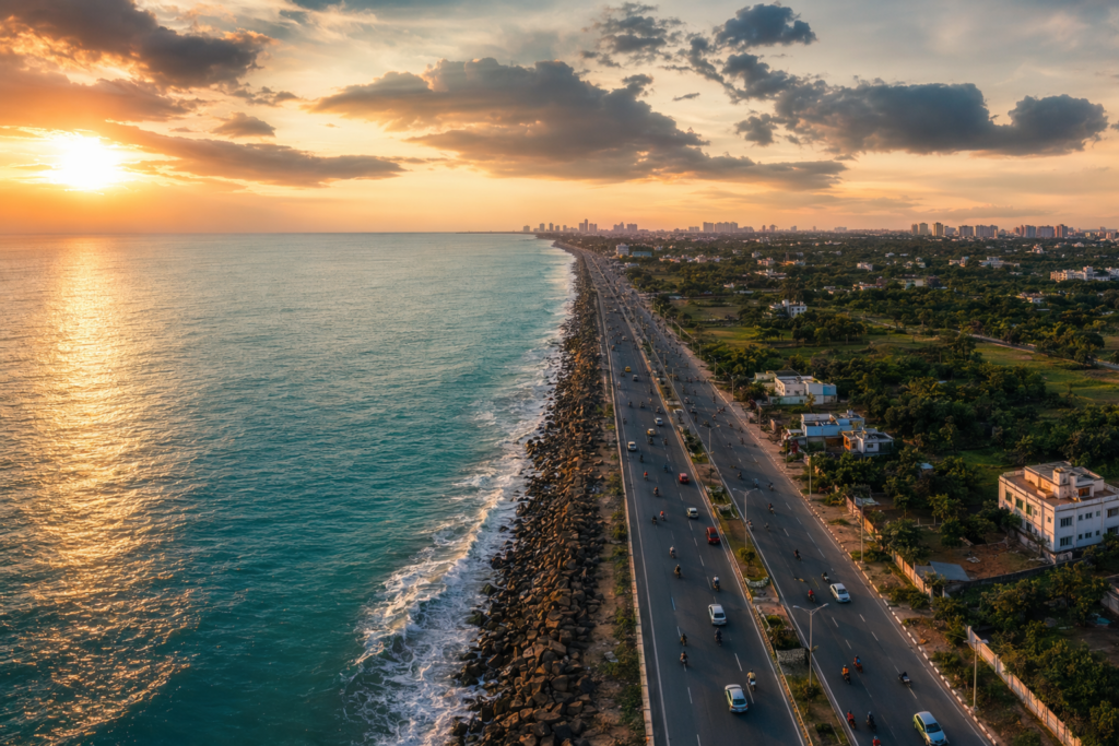
East Coast Road (ECR) — Chennai’s most sought-after coastal corridor. Image: AI-generated aerial view.
Introduction: The Dream That Turns Into a Legal Nightmare
East Coast Road. Sea breeze. Beautiful roads. Resort vibes. For decades, ECR has been marketed as Chennai’s premium coastal real estate corridor — the place where you build your dream beach house, your weekend getaway, your retirement villa.
But here’s what your broker won’t tell you: up to 8 different government restrictions can stack on a single ECR plot — Coastal Regulation Zone (CRZ), Aquifer Recharge Zone, ASI Monument Buffer, Buckingham Canal Buffer, Burial Ground Buffer, Flood Inundation Zone, Temple Trust Land (HR&CE), and Turtle Nesting Zone. Each one independently limits what you can build. When they overlap — and on ECR, they almost always do — the result is devastating.
We didn’t rely on hearsay or broker claims. At LandLens, we analyzed 23,441 FMB-level land parcels from government records across 12 villages — from Kottivakkam in the north to Mahabalipuram in the south. That’s 8,800+ acres of ECR land, every parcel checked against government-notified restriction zone boundaries. The result: over 6,100 acres (69.5%) of the ECR corridor falls in one or more government-restricted zones.
Every number in this article is backed by government data. Every claim is sourced. This isn’t fear-mongering — it’s the reality that anyone spending crores on ECR land needs to understand before signing.
1. Squeezed Between Sea and Canal
To understand why ECR is so restricted, you need to understand its geography. The corridor is a narrow strip of land sandwiched between the Bay of Bengal to the east and the Buckingham Canal to the west. Both are regulated water bodies under CRZ law.
The Bay of Bengal generates CRZ buffers from the east. The Buckingham Canal — classified as a tidal water body — generates its own CRZ buffer of 100 meters on each side from the west. ECR sits right in the middle where these buffers overlap. In some stretches, there is literally zero buildable land left between the two buffer zones.
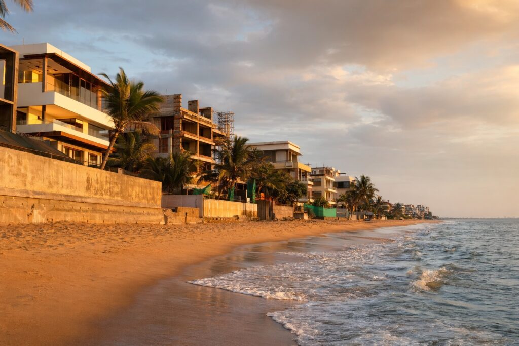
Villas and buildings encroaching right up to the ECR coastline. Image: AI-generated illustration.
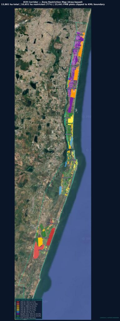
LandLens CRZ corridor map: Each colored polygon is an actual government FMB land parcel, classified by CRZ zone. Source: CRZ Notification 2019 (MoEFCC); TNGIS CRZ zone data.
2. CRZ — The Invisible Wall You Can’t See
The Coastal Regulation Zone (CRZ) Notification 2019, issued by the Ministry of Environment, Forest & Climate Change (MoEFCC), divides all coastal land into zones based on ecological sensitivity and existing development. Each zone has different rules for what you can — and cannot — build. Here’s what each zone means for your ECR property:
| CRZ Zone | What You Can Build | Buffer / NDZ |
| CRZ-1A | NOTHING — Mangroves, eco-sensitive areas | Total construction ban |
| CRZ-1B | NOTHING — Inter-tidal zone (between HTL & LTL) | Total construction ban |
| CRZ-2 | Limited — FSI capped at 1.5, no premium FSI | Must have existing road/structure between plot & HTL |
| CRZ-3A | Beyond 50m NDZ only, G+1 max height | 50 meters from High Tide Line (HTL) |
| CRZ-3B | Beyond 200m NDZ only, G+1 max height | 200 meters from HTL |
Key takeaways: CRZ-1 means you CANNOT build. Period. CRZ-2 lets you build but FSI is capped at 1.5 and premium FSI is not applicable. CRZ-3 restricts you to beyond the No Development Zone (NDZ) only, and height is capped at ground + 1 floor. Even a DTCP-approved layout on ECR is subject to separate CRZ clearance from TNCZMA. “Approved plot” does not mean “approved to build what you want.”
CRZ Impact: The Numbers
Our spatial analysis of 23,441 land parcels reveals the scale of CRZ impact across the ECR corridor:
| Restriction Category | Area (Hectares) | % of ECR Corridor |
| CRZ + Aquifer Overlap (double restriction) | 406 ha | 11.4% |
| CRZ-3A (50m NDZ) | 404 ha | 11.3% |
| CRZ-1B (ABSOLUTE BAN — inter-tidal) | 365 ha | 10.2% |
| CRZ-3B (200m NDZ) | 180 ha | 5.0% |
| CRZ-1A (ABSOLUTE BAN — mangroves/eco) | 165 ha | 4.6% |
| CRZ-4B (Water body buffer) | 99 ha | 2.8% |
| CRZ-2 (FSI 1.5 max) | 3 ha | 0.1% |
| Total CRZ-Affected | 1,622 ha | 45.4% |
| Aquifer Only (no CRZ, but FSI 0.8) | 862 ha | 24.1% |
Nearly half (45.4%) of the ECR corridor is in some form of CRZ. Add the Aquifer-only areas (862 ha, 24.1%) and the total restricted land reaches 2,484 hectares — 69.5% of the entire ECR corridor. Only 30.5% has no restrictions. And this is BEFORE counting ASI buffers, burial grounds, temple trust lands, flood zones, and road widening.
Source: CRZ Notification 2019 (MoEFCC), G.S.R. 37(E), dated 18 January 2019; LandLens spatial analysis of TNGIS CRZ zone data.
3. The Aquifer Recharge Zone — The Restriction Your Broker Doesn’t Know
Most ECR buyers have never heard of the Aquifer Recharge Zone. But it hits harder than CRZ on what you can actually build. The coastal aquifer beneath Chennai’s ECR corridor is a critical freshwater resource. To protect it, the Tamil Nadu Combined Development and Building Rules (TNCDBR 2019) impose severe construction restrictions in this zone — restrictions that slash your building potential by more than half.
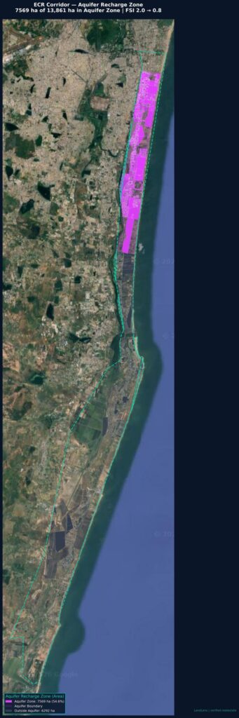
LandLens Aquifer Zone map: Magenta plots are in the Aquifer Recharge Zone. Source: TNCDBR 2019 Annexure XVII.
Here’s how the Aquifer Zone decimates your building potential compared to a normal residential zone:
| Parameter | Normal Zone | Aquifer Zone | Impact |
| FSI (Floor Space Index) | 2.0 | 0.8 | -60% |
| Ground Coverage | 80% | 40% | -50% |
| Maximum Height | 14m (Stilt+3) | 9m (Stilt+2) | -36% |
| Minimum Plot Size | No minimum | 220 sq.m | New barrier |
| Minimum Frontage | 3 meters | 12 meters | 4x more required |
| Premium FSI | Eligible | BLOCKED | Not available |
| High-Rise Construction | Allowed | PROHIBITED | Banned entirely |
When Aquifer and CRZ zones overlap — which they do across large parts of northern ECR — the system applies the stricter rule for each parameter. The Aquifer Zone affects 1,268 hectares (35.5%) of the ECR corridor, concentrated in the northern stretch from Kottivakkam to Kanathur. In five villages (Sholinganallur-2, Injambakkam, Neelangarai, Kottivakkam, and Palavakam), 96% to 99% of land is in the Aquifer Zone.
Northern ECR (5 villages): 96–99% in Aquifer Zone — FSI drops from 2.0 to 0.8. Southern ECR: No aquifer restriction, but CRZ kills everything instead. There is no stretch of ECR where you escape both.
Source: TNCDBR 2019 Annexure XVII Clause 5(i), Page 179; G.O. Ms. No. 69 (2024), Housing & Urban Development Dept, Government of Tamil Nadu.
4. The Math That Hurts — 5,000 sqft on ECR = 2,000 sqft in Adyar
This is where it gets personal. Let’s compare two real scenarios — a 5,000 sqft plot in Neelangarai (ECR, Aquifer + CRZ-2 zone) versus a 2,000 sqft plot in Adyar (normal residential zone). Same city, vastly different outcomes.
Plot A: 5,000 sqft in Neelangarai (ECR) — Aquifer Zone + CRZ-2
| Parameter | Value |
| FSI | 0.8 |
| Ground Coverage | 40% |
| Maximum Height | 9m (Stilt + 2 floors) |
| Premium FSI | BLOCKED |
| Maximum Built-up Area | 4,000 sqft |
| Floors | 2 only |
Plot B: 2,000 sqft in Adyar — Normal Residential Zone
| Parameter | Value |
| FSI | 2.0 |
| Ground Coverage | 80% |
| Maximum Height | 14m (Stilt + 3 floors) |
| Premium FSI | Up to 2.5 |
| Maximum Built-up Area | 4,000 sqft (5,000 sqft with premium) |
| Floors | 3 (or more with premium) |
Same 4,000 sqft built-up area. But the ECR buyer needs 2.5x MORE land to get it. The Adyar buyer pays less for land and gets up to 5,000 sqft with premium FSI. The ECR buyer pays MORE, gets the SAME (or less), and can’t even go above 2 floors. Premium FSI — which can add 25% more built-up area in normal zones — is completely blocked in Aquifer and CRZ zones.
Source: TNCDBR 2019 Annexure XVII, Rule 36, Rule 49; G.O. Ms. No. 69 (2024).
5. Village-by-Village: How Much of ECR Is Actually Usable?
We mapped every village along the ECR corridor — from Kottivakkam in the north to Pattipullam in the south. Here’s how each village fares when you overlay all government restriction zones. The data is sorted from worst (most restricted) to least restricted.
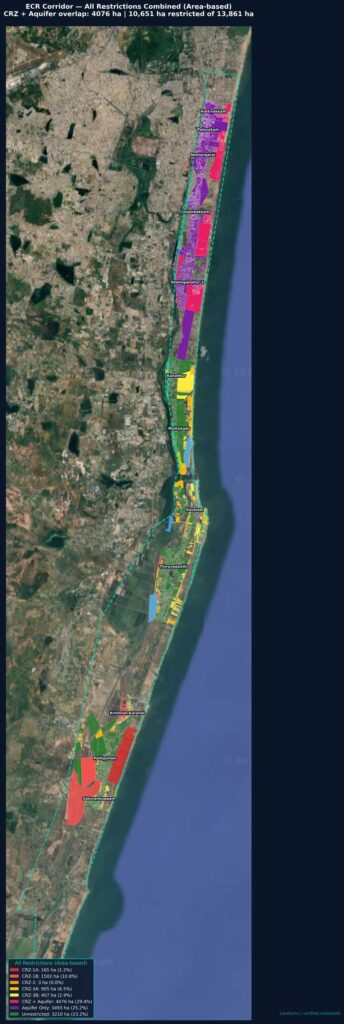
LandLens combined restriction map: All CRZ + Aquifer zones overlaid on satellite imagery. Source: LandLens spatial analysis of government zone data.
| Village (N→S) | Total Area | Restricted | % Restricted | Dominant Restriction |
| Sholinganallur-2 | 360 ha | 358 ha | 99.6% | Aquifer (210 ha) + CRZ+Aquifer (146 ha) |
| Injambakkam | 356 ha | 350 ha | 98.4% | Aquifer (229 ha) + CRZ+Aquifer (119 ha) |
| Kottivakkam | 104 ha | 102 ha | 98.3% | Aquifer (66 ha) + CRZ+Aquifer (35 ha) |
| Neelangarai | 221 ha | 217 ha | 98.3% | Aquifer (130 ha) + CRZ+Aquifer (87 ha) |
| Palavakam | 138 ha | 134 ha | 96.5% | Aquifer (114 ha) |
| Saluvankuppam | 295 ha | 256 ha | 86.7% | CRZ-1B (227 ha!) |
| Kovalam | 43 ha | 35 ha | 79.7% | CRZ-3A (23 ha) + CRZ-3B (10 ha) |
| Krishnan Karanai | 56 ha | 35 ha | 62.8% | CRZ-1B (24 ha) |
| Kanathur | 357 ha | 208 ha | 58.2% | Aquifer (112 ha) + CRZ-3B (84 ha) |
| Muttukadu | 300 ha | 160 ha | 53.2% | CRZ-3A (112 ha) |
| Pattipullam | 800 ha | 381 ha | 47.6% | CRZ-1A (165 ha!) + CRZ-3A (119 ha) |
| Thiruvedanthi | 543 ha | 249 ha | 45.8% | CRZ-3A (113 ha) + CRZ-3B (63 ha) |
| TOTAL | 3,574 ha | 2,484 ha | 69.5% | Combined CRZ + Aquifer |
Five villages are 96% or more restricted — virtually zero freely buildable land. Saluvankuppam (near Mahabalipuram) has 227 hectares of CRZ-1B, which is inter-tidal zone with zero construction allowed. Pattipullam has 165 hectares of CRZ-1A and 97 hectares of CRZ-1B — a combined 262 hectares of absolute construction ban. Even the “least restricted” village, Thiruvedanthi, still has 46% of its land in restricted zones.
Source: LandLens spatial analysis — union of 23,441 FMB parcels from government land records, clipped to ECR corridor, areas computed in UTM 44N projection (EPSG:32644).
6. Mahabalipuram: The 300-Meter Kill Zone
If you’re considering buying land near Mahabalipuram, there’s another restriction layer that most buyers don’t even know exists — the Ancient Monuments and Archaeological Sites and Remains (AMASR) Act, 1958 (amended 2010).

The Shore Temple, Mahabalipuram — UNESCO World Heritage Site. Every ASI monument creates a 100m prohibited + 200m regulated buffer zone. Image: AI-generated illustration.
Mahabalipuram has 43 ASI-protected monuments and 33 archaeological sites. Each one creates its own buffer zone under the AMASR Act:
| Zone | Distance from Monument | Rule |
| PROHIBITED AREA | 0–100 meters | ABSOLUTE construction ban. Violation: up to 2 years imprisonment + ₹1 lakh fine (Section 30A) |
| REGULATED AREA | 100–300 meters (total) | NMA (National Monuments Authority) permission required. Building height cannot exceed monument height |
Key monuments creating massive overlapping buffers include the Shore Temple (right on the beach), Pancha Rathas (5 monolithic temples), Arjuna’s Penance (world’s largest open-air rock relief), Tiger Cave (4.5 km from town, directly on ECR), and Saluvankuppam excavation site (200m from Shore Temple). These 100m/300m buffers from 43+ monuments overlap with each other, creating massive swathes of completely unbuildable land near Mahabalipuram town.
And these ASI buffers stack on top of CRZ. Saluvankuppam village alone is 86.7% CRZ-restricted PLUS ASI monument buffers. It’s a double legal minefield.
Source: AMASR Act 1958 (amended 2010), Sections 20A, 20B, 30A; ASI Chennai Circle — Mamallapuram Sub-Circle monument list.
7. The Alavandar Trust Trap — 1,050 Acres of Temple Land on ECR
There’s a piece of ECR history your broker definitely won’t tell you.
In 1877, Sri Alavandar Naicker — known as “Ayiram Kaani Alavandar” (Owner of 1,000 Kaani) — acquired approximately 1,300 acres of coastal land along the ECR corridor. Before his death in 1914, he willed ALL of it to temple charities. Today, “Nemmeli Arulmigu Alavandar Nayagar Charities” owns approximately 1,050 acres across five villages: Pattipullam, Saluvankuppam (Mahabalipuram), Krishnan Karanai, Kovalam, and Nemmeli. The trust has been controlled by the HR&CE Department since 1949. Estimated current value: over Rs 1,000 crore.
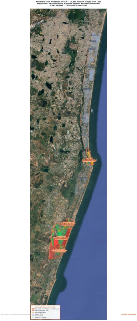
LandLens map showing Alavandar Trust villages highlighted along southern ECR. Source: LandLens spatial analysis.
This is temple trust land. You cannot get clear title. Here’s what’s happening with it right now:
184 encroachers identified by HR&CE on the trust lands. 18 acres recovered through court orders (as of February 2026). Madras High Court ordered criminal prosecution against a claimant who used forged documents to grab approximately 1,000 acres. The HC blocked the sub-registrar from issuing Encumbrance Certificates (ECs) to prevent fake title chains. A Dargah was found encroaching on trust land — Section 78 proceedings initiated. PMK/Vanniyar Sangam stalled HR&CE’s attempt to commercially lease 60 acres of the trust land. In a separate but connected case, 226 acres were recovered for Thiruporur Murugan Temple in a massive eviction drive on 7 February 2026 — the HC closed the contempt case after Rs 700 crore worth of temple lands were recovered.
These 1,050 acres sit in exactly the villages we analyzed above — Pattipullam (48% restricted by CRZ/Aquifer), Saluvankuppam (87% restricted), Krishnan Karanai (63% restricted), Kovalam (80% restricted). So it’s CRZ + Temple Trust Land — a double legal minefield. If someone offers you “ECR land near Mahabalipuram,” ask: “Is this Alavandar Trust land?” Watch them go silent.
Sources: Madras HC orders (W.P. 27292/2015, decided Aug 2022); HR&CE Department records; DT Next (July 2023, Nov 2024); The Commune (Feb 2026).
8. The Enforcement Reality — Demolitions Are Happening
“But sir, look at all these buildings on ECR! So many beautiful villas — how can you say we can’t build?” This is the most common argument brokers use. Here’s why those buildings exist — and why yours won’t survive:
Pre-1991 structures were built before the CRZ notification existed. Your new construction doesn’t get this exemption. Unauthorized buildings — 798 ECR buildings received GCC demolition notices in 2018, including properties linked to Udhayanidhi Stalin, Kamal Haasan, and Vijay. Court stays exploited — developers obtain temporary High Court stays and keep building. When the stay is vacated, demolition follows.
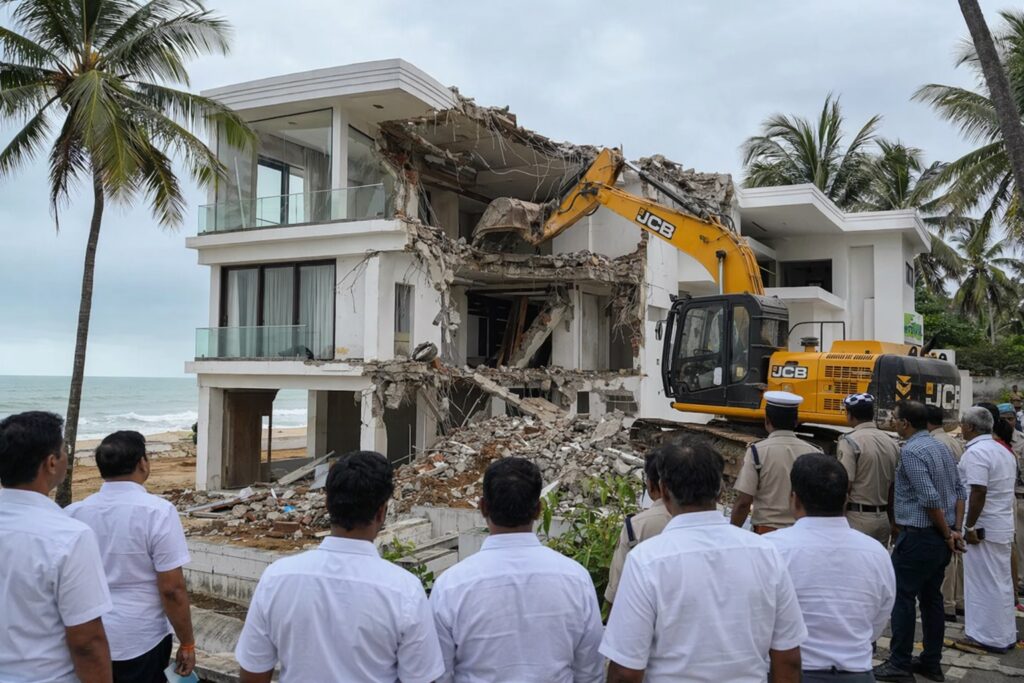
Coastal villa demolition — CRZ violations have real consequences. Image: AI-generated illustration inspired by Maradu demolitions, Kochi (2020).
Here are real enforcement cases — every one of these was someone’s “dream investment”:
| Case | What Happened | Source |
| Maradu, Kochi (Jan 2020) | 4 luxury apartment complexes IMPLODED by controlled demolition. Supreme Court order. 300+ families displaced. Builders had HC stays — SC reversed them ALL. | SC Civil Appeal 4784/2019 |
| 798 ECR Buildings (2018) | GCC issued demolition notices to 798 buildings between Neelankarai and Uthandi for CRZ violations. Properties of Udhayanidhi, Kamal, Vijay included. | DT Next, The News Minute |
| 22 Muttukadu Buildings (2025) | Facing demolition. Some just 30–50m from sea. GPS-tagged inspection submitted to TNSCZMA. Developers: Olive Resorts, Agni Estates. | Constro Facilitator, DT Next |
| 440 Pending ECR Appeals | Out of 798, only 84 disposed as of Feb 2026. Madras HC set May 31, 2026 deadline to dispose ALL remaining appeals. | DT Next (Feb 2026) |
| Rs 200 Cr Seven-Star Resort | Demolished. Supreme Court upheld demolition order for CRZ violations. | SC Orders |
Unless you have throw-away money, never develop in restricted zones. The Maradu case proved that even luxury apartments with High Court stays are not safe — the Supreme Court ordered controlled implosion of all four complexes. The same can happen on ECR.
9. What’s Actually Legal on ECR
Not everything is banned. But the exceptions are razor-thin and very specific:
| Zone / Condition | What’s Permitted |
| CRZ-2 with TNCZMA clearance | FSI 1.5 max. Landward side of existing road ONLY. Premium FSI NOT applicable. |
| CRZ-3 beyond NDZ | Hotels/resorts with approved tourism plan ONLY. Houses for local communities (traditional dwellings). Schools, dispensaries, public facilities. |
| CRZ-3 WITHIN NDZ | Agriculture, parks, playfields ONLY. No permanent structures allowed. |
| Existing authorized structures | Repairs at SAME FSI, same plinth, same density. NO expansion, NO change of use. |
If your broker can’t show you a CRZ clearance certificate from TNCZMA, building plan approval from CMDA/DTCP, and environmental clearance (if applicable) — run.
Source: CRZ Notification 2019 Clause 5; TNCDBR 2019.
10. Five Questions to Ask Your Broker Before You Sign
If you’re still considering an ECR property after reading all of the above, at a minimum, ask your broker these five questions. Demand documented answers — not promises.
| # | Question | Why It Matters |
| 1 | “Show me the CRZ clearance certificate from TNCZMA.” | If they can’t produce it, the plot is NOT cleared for construction in CRZ. |
| 2 | “Is this in the Aquifer Recharge Zone?” | If yes, FSI drops to 0.8, coverage to 40%, height to 9m. No premium FSI. No high-rise. |
| 3 | “Is this land part of Alavandar Trust or any HR&CE temple endowment?” | If yes, title is legally contested. HC has blocked EC issuance for such lands. |
| 4 | “Show me building plan approval from CMDA/DTCP.” | “Layout approved” does NOT mean “you can build what you want.” CRZ still applies separately. |
| 5 | “Is there any ASI monument within 300 meters?” | If yes: 0–100m = total ban with criminal penalty. 100–300m = NMA permission, height capped. |
If your broker can’t answer ALL five with documents — not promises, not “sir it will be fine,” not “everyone builds here” — walk away. The crores you save could be the smartest investment decision of your life.
Before you take the next step on any ECR property, don’t rely only on verbal assurances, brochure claims, or “sir, everyone is building here” explanations. Check the land yourself on LandLens by Verified.RealEstate. Enter the property location and get instant insights on CRZ, Aquifer Recharge Zone, ASI monument buffers, flood risk, burial ground proximity, temple/HR&CE risks, road widening, zoning restrictions, and more — all mapped to your specific plot. A few minutes of checking can save you from years of legal trouble, blocked approvals, or a demolished dream project.
Visit: https://verified.realestate/landlens/verify-my-land
Check Before You Buy. Not After You Cry.

Everything in this article — every CRZ zone check, every aquifer restriction, every ASI buffer, every burial ground proximity, every flood zone overlap — LandLens does for YOUR specific plot. In 2 minutes.
LandLens “Verify My Land” runs 30+ automated checks on any property in Tamil Nadu:
| Category | Checks |
| Environmental | CRZ | Aquifer | Eco-Sensitive Zone | Ramsar | Reserve Forest |
| Heritage | ASI Monuments | Temple Land (HR&CE) | WAQF |
| Hazards | Flood Zone | Burial Ground | Quarry | HT Line |
| Infrastructure | Metrowater | Sewage | Railway | Road Widening |
| Zoning | Master Plan | CBA | Airport NOC | Defence Zone |
Every check shows the exact distance from your plot, the legal source (Act / GO / Notification), and the impact on FSI, height, and coverage. Plus our Build Scope Calculator — enter your plot dimensions and get the exact buildable area accounting for every restriction that applies.
Don’t trust the broker. Trust the data.
Google “LandLens Verify My Land” or visit verified.realestate
Before anything in real estate, think Verified.RealEstate.
Sources & References
Every URL below was HTTP-verified on 18 May 2026. All claims in this article are backed by these government, court, and news sources.
Legal / Government Sources
1. CRZ Notification 2019 — G.S.R. 37(E), dated 18 January 2019, MoEFCC. Zone classifications, NDZ distances, permitted activities. PDF: http://www.sczmaodisha.org/pdf/CRZ%20Notification%202019%20English.pdf | Full text: https://crz.elaw.in/crz2019.html
2. TNCDBR 2019 — G.O. Ms. No. 118, Housing & Urban Development Dept. Rule 36 (FSI 2.0), Rule 49 (Premium FSI), Annexure XVII Clause 5(i) Page 179 (Aquifer Zone rules). PDF: https://chennaicorporation.gov.in/gcc/online-services/town-planning/TNCDRBR-2019.pdf | CMDA: https://www.cmdachennai.gov.in/TNCDBR2019.html
3. G.O. Ms. No. 69 (2024) — Aquifer zone amendment. Housing & Urban Development Dept, Government of Tamil Nadu, dated 11 March 2024. TN Gazette: https://archive.org/details/in.gazette.tamilnadu.2024-03-11.Extraordinary_100_Part-III_Section-1A | News: https://www.dtnext.in/news/tamilnadu/tn-relaxes-coastal-aquifer-zone-rules-to-allow-white-industries-849628
4. AMASR Act 1958 (amended 2010) — Section 20A (100m prohibited area), Section 20B (200m regulated area), Section 30A (penalties). PDF: https://www.indiacode.nic.in/bitstream/123456789/15477/1/the_ancient_monuments_and_archaeological_sites.pdf
5. ASI Tamil Nadu monument list: https://asi.nic.in/alphabetical-list-of-monuments-tamil-nadu/ | ASI Chennai Circle — Mamallapuram Sub-Circle: https://asichennai.gov.in/mamallapuram_sub_circle.html
Demolition Cases & Enforcement
6. Maradu Apartment Demolitions, Kochi (Jan 2020) — SC Civil Appeal 4784/2019. Wikipedia: https://en.wikipedia.org/wiki/Maradu_apartments_demolition_order | The News Minute: https://www.thenewsminute.com/article/we-ll-never-forget-pain-evictees-recall-2020-maradu-flats-demolition-141279
7. 798 ECR Buildings — GCC Notices (2015–2018) + 440 Pending Appeals. DT Next (Feb 2026): https://www.dtnext.in/news/chennai/crz-violations-by-resorts-and-sea-side-bungalows-may-31-set-for-disposal-of-ecr-construction-violation-appeals-mhc | The News Minute (Nov 2019): https://www.thenewsminute.com/tamil-nadu/hc-pulls-chennai-civic-bodies-allowing-unauthorised-construction-along-ecr-113180 | Deccan Chronicle (Mar 2018): https://www.deccanchronicle.com/nation/current-affairs/210318/548-unauthorised-structures-in-crz-iii-area-get-notices.html
8. 22 Muttukadu Buildings — NGT/Demolition (2025). Constro Facilitator: https://constrofacilitator.com/22-sea-facing-buildings-on-ecr-face-demolition/ | DT Next: https://www.dtnext.in/news/chennai/illegal-constructions-in-crz-iii-zone-cause-concern-among-activists-and-fishermen-in-muttukadu-830140
9. ECR Builders in Jitters — HC Orders (2020). DT Next: https://www.dtnext.in/city/2020/01/28/builders-in-jitters-over-hc-order-on-crz-breach-on-ecr
Alavandar Trust / HR&CE
10. HR&CE Auction Controversy (July 2023). DT Next: https://www.dtnext.in/news/tamilnadu/hrce-bid-to-auction-alavandar-trust-land-stalled-following-pmks-opposition-723769
11. HR&CE — 184 Encroachers Identified (Nov 2024). DT Next: https://www.dtnext.in/news/tamilnadu/will-retrieve-kandaswamy-temple-and-alavandar-trust-lands-soon-state-to-hc-812694
12. 226 Acres Retrieved — Massive Eviction Drive (Feb 2026). The Commune: https://thecommunemag.com/226-acres-retrieved-madras-high-court-records-massive-thiruporur-murugan-temple-land-recovery | DT Next (contempt closed): https://www.dtnext.in/news/tamilnadu/madras-hc-closes-contempt-case-after-recovery-of-temple-lands-worth-rs-700-crore | Swarajya: https://swarajyamag.com/news-brief/madras-high-court-comes-to-the-rescue-of-skanda-temple-and-charity-trust-lands-near-chennai
LandLens Data & Enforcement Lists
13. LandLens Verify My Land Tool: https://verified.realestate/landlens/verify-my-land — 23,441 FMB-level parcels analyzed from government land records (tn_land_details), intersected with CRZ zone polygons (13,711 records from TNGIS/MoEFCC), Aquifer Recharge Zone boundary, and 18 burial grounds within ECR corridor. Union area computation in UTM 44N (EPSG:32644) projection.
14. CMDA Violation List: https://cmdachennai.gov.in/Violation.html | CMDA Lock/Seal/Demolition Notices: https://cmdachennai.gov.in/LSDNoticeIssued.html
15. Verified.RealEstate Community Articles: https://community.verified.realestate/article/madras-high-court-orders-disposal-of-440-crz-appeals-along-chennai-ecr-by-may-31/ | https://community.verified.realestate/article/muttukadu-beachfront-villas-to-be-demolished-for-crz-violations-says-district-report/
Disclaimer
This content is for educational and informational purposes only. It is not legal advice. Property regulations can change, and specific plot-level restrictions depend on exact location, patta classification, and applicable government orders at the time of application. Always consult a qualified legal professional and verify with the relevant authorities (TNCZMA, DTCP, CMDA, NMA) before making any property purchase or construction decisions. LandLens provides data-driven insights but does not replace professional legal counsel.