1. Introduction
In Tamil Nadu, land is often identified by survey numbers, but actual boundaries on the ground are confirmed only through the FMB Sketch — a vital yet often overlooked land record. FMB stands for Field Measurement Book, and it contains detailed survey drawings that determine the precise shape, measurements, and boundary lines of land parcels.
Whether you’re buying a small plot or verifying inherited property, the FMB sketch is critical for preventing boundary disputes and encroachments.
2. What is an FMB Sketch?

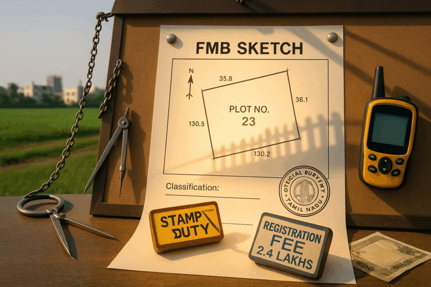
An FMB Sketch is an official, scaled field drawing prepared by the Tamil Nadu Survey Department based on physical ground measurements. It records each survey number’s:
- Shape and dimensions
- Adjacent survey numbers
- Subdivision layout
- Orientation and angles
- Pathways, roads, water bodies, or government lands nearby
FMB sketches are prepared by licensed surveyors using chain and compass or GPS instruments, and they serve as the legal boundary reference in land disputes.
3. Why is the FMB Sketch Important?
FMB sketches are used for:
- Demarcation of land boundaries before registration
- Resolving boundary disputes between neighbours
- Verifying layout approval claims
- Detecting overlaps into OSR land, water bodies, or poramboke areas
- Supporting DTCP/CMDA building permissions
- Establishing undivided share (UDS) in apartments
4. Key Elements in an FMB Sketch
Here’s what you’ll typically find in a Tamil Nadu FMB sketch:
| Element | Meaning |
|---|---|
| Survey Number/Subdivision | Unique identifier for the land parcel |
| Scale and Measurement | Exact scale used (e.g., 1:1000) and all side measurements |
| North Direction | Arrow to orient the sketch |
| Boundary Lines | Each side is marked with length (in links/metres) |
| Adjacent Survey Numbers | Lists neighbouring plots |
| Symbols/Features | Roads, irrigation channels, poramboke, structures, etc. |
| Signature and Seal | Signed by a licensed surveyor or VAO |
5. FMB vs Layout Sketch vs Village Map
Many buyers confuse the FMB Sketch with layout plans or revenue maps. Here’s the difference:
| Document | Purpose | Source |
|---|---|---|
| FMB Sketch | Shows detailed dimensions of one plot | Survey Department |
| Layout Sketch | Shows entire colony/project division | Developer or DTCP |
| Village Map | High-level view of entire village/town | Revenue Department |
If accuracy is your goal — to know how much land physically exists and where the borders fall — the FMB sketch is the gold standard.
6. How to Access an FMB Sketch in Tamil Nadu
You can get your FMB sketch through two main channels:
A. Online (Digital FMB Extract – if available)

- Visit: https://eservices.tn.gov.in
- Click “View Patta/Chitta/FMB Extract”
- Choose:
- District
- Taluk
- Village
- Survey Number / Subdivision
- Submit OTP and download the sketch
Note: Not all villages or towns have digitized FMBs. Some may only be available at the Taluk office.
B. Offline (Manual Request)
- Visit the Taluk Office or VAO with property details
- Submit a written request or application form
- Provide a copy of Patta or Sale Deed
- Pay nominal fee (₹30–₹100 depending on mode)
- Processing time: 3–7 working days
7. Final Checklist Before Purchase
✅ Ask for FMB Sketch + Patta + EC
✅ Compare layout sketch with FMB lines
✅ Check for path overlaps or poramboke claims
✅ Use official FMB to apply for layout or building plan approval
✅ Do not rely solely on boundary stones or fencing on-site
We uncover what layouts and brokers won’t show you. Click here!
Conclusion
The FMB Sketch is your legal map of truth when it comes to land boundaries in Tamil Nadu. Unlike marketing brochures or layout drawings, it reflects what the government surveyor saw, measured, and documented on record.
Before you register, build, or invest in land, let the FMB sketch confirm what you’re actually getting.