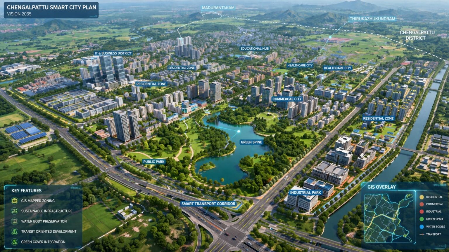
📍 Chengalpattu Master Plan 2026 – What’s New?
The Tamil Nadu government has initiated a major urban planning push in Chengalpattu, with the Directorate of Town and Country Planning (DTCP) actively preparing a GIS-based master plan. Unlike previous broad proposals, this is a data-driven and zone-focused strategy aimed at structured development.
The plan prioritizes high-growth regions such as Madurantakam and Thirukazhukundram, marking a shift toward targeted urban expansion instead of district-wide planning.
🧭 GIS-Based Planning: A Major Shift
One of the most significant updates is the adoption of GIS (Geographic Information System) technology for planning.
This includes:
- Satellite-based land mapping
- Real-time surveys
- Scientific land-use classification
This approach ensures:
- Accurate zoning (residential, commercial, industrial)
- Reduced planning errors
- Better infrastructure alignment
👉 This marks a transition from generic layouts to precision urban planning.
🌍 Global City Vision for Madurantakam
A key highlight of the 2026 update is the positioning of Madurantakam as a future “Global City” hub.
The proposed development includes:
- Integrated townships
- IT and business zones
- Social infrastructure (schools, hospitals)
- Smart mobility systems
The planning framework is inspired by international urban models like NEOM Smart City Model (Saudi Arabia), focusing on sustainability, smart infrastructure, and long-term scalability.
📍 Planned Changes in Thirukazhukundram
Under the Chengalpattu Master Plan 2026, Thirukazhukundram is identified as a key growth node with structured zoning and infrastructure upgrades. The plan proposes improved road connectivity, better water and drainage systems, and designated residential and commercial zones supported by GIS-based land-use planning.
Thirukazhukundram, known for its spiritual and tourism significance, will be developed with modern infrastructure while preserving its cultural and heritage character. These changes aim to transform the area from a semi-urban temple town into a well-planned urban extension with balanced development and improved livability.
📐 Defined Planning Area – Focused Development Strategy
The master plan currently covers approximately 146.26 sq. km, indicating a focused corridor-based development model.
Instead of spreading resources across the entire district, the government is:
- Prioritizing high-impact zones
- Planning phased expansion
- Ensuring infrastructure readiness before growth
🚧 Infrastructure-Led Development Approach
The latest consultations emphasize infrastructure-first planning, including:
- Wider road networks and transport corridors
- Improved water supply systems
- Underground drainage infrastructure
- Transit-Oriented Development (TOD) concepts
- Higher Floor Space Index (FSI) near transport hubs
👉 This signals a move toward planned, congestion-free urbanization.
⏳ Timeline and Current Status
As per the latest updates:
- Next 24 months: Surveys, stakeholder consultations, and draft plan preparation
- Post-approval phase: Implementation expected around 2027–2028
Currently, the project remains in the planning and policy stage, with execution yet to begin.
⚖️ Policy Support: Faster DTCP Approvals
Parallel reforms in Tamil Nadu are strengthening the master plan’s impact:
- Online DTCP approval systems
- Single-window clearance mechanisms
- Faster approvals for layouts and buildings
This improves:
- Ease of doing real estate transactions
- Developer confidence
- Project execution timelines
⚠️ Ground Reality Check
While the plan is ambitious, key challenges remain:
- Existing infrastructure gaps
- Dependence on execution efficiency
- Long gestation period
👉 The success of this master plan will depend more on implementation than intent.
📊 What This Means for Buyers & Investors
- Chengalpattu is evolving into a major Chennai satellite growth corridor
- Early-stage investment opportunities may emerge in targeted zones
- However, short-term gains are uncertain
- Long-term potential (5–10 years) looks promising if execution aligns with planning
- The 46.26 sq. km planning area means the government is not developing the entire Chengalpattu district at once, but focusing on a specific high-growth corridor. This targeted approach allows for better infrastructure planning, controlled urban expansion, and faster implementation. ↩︎