



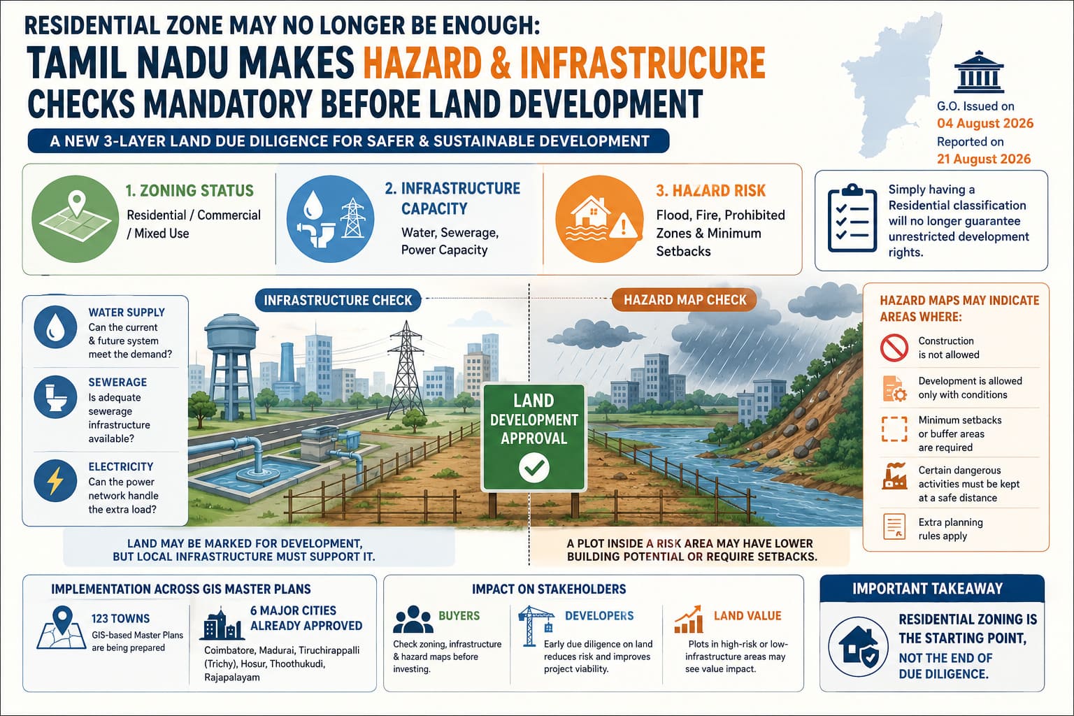
When buying land, many people first check whether the planning map marks the plot as “Residential.” However, a new Tamil Nadu government order may require buyers to ask two more important questions:
Can the local infrastructure support new construction? Is the land in an area at risk from floods, landslides, fires or other hazards?
The order was issued by the Tamil Nadu Housing and Urban Development Department.
- Order date: August 4, 2026
- Directive: Planning authorities must include natural-hazard checks and major infrastructure capacity in land-use planning and zoning rules.
Following a DTCP proposal, the order reported on August 21, 2026, makes it clear that residential zoning alone will no longer guarantee unrestricted development or construction rights.
This is important for landowners, developers, investors and homebuyers because a residential zoning label may no longer show the full development potential of a property.
Three Important Checks Before Buying Land
Land-use decisions will now need to look beyond a simple Residential or Commercial label.
Property checks can be understood through three main areas:
| Check | What it tells you |
|---|---|
| Zoning Status | Whether the land can be used for homes, shops, mixed use or another approved purpose |
| Infrastructure Capacity | Whether water, sewerage and electricity systems can support current and future construction |
| Hazard Risk | Whether the land is in a flood-prone, restricted, prohibited or otherwise unsafe area |
This means a plot may have residential zoning but still face building limits because of weak infrastructure or hazard-related rules.
Why Is Tamil Nadu Adding These Checks?
The government wants to reduce the problems caused by unplanned development.
When large areas are developed without checking infrastructure and safety risks, the results may include:
- Overloaded water-supply systems
- Poor or insufficient sewerage systems
- Extra pressure on electricity networks
- Construction in flood-prone or low-lying areas
- Greater risk from natural disasters
- Traffic problems
- Pressure on public services
The new system aims to check these issues before development begins, instead of dealing with them after construction has already taken place.
Infrastructure & Hazard Checks: Two New Layers in Land Planning
Hazard risk is only one part of the new planning approach.
Hazard mapping is the process of identifying and mapping areas vulnerable to risks such as floods, landslides, fires and other natural or man-made hazards to guide safer development.
Before development, planning authorities will also assess whether essential infrastructure such as
- water supply,
- sewerage and
- electricity can support the proposed development.
At the same time, hazard maps will identify areas vulnerable to risks such as floods, landslides, fires and other natural or man-made hazards.
Depending on the risk, these maps may indicate
- **prohibited construction areas, **
- **special development conditions, **
- **minimum setbacks or **
- buffer zones, and other planning restrictions.
This means a plot being marked “Residential” does not necessarily mean unrestricted construction. A property may have lower development potential if it has inadequate infrastructure or falls within a mapped risk area. For example, two plots of the same size could have different usable areas if one is subject to additional setbacks or safety buffers.
Hazard Maps Will Be Available for Public Review
The order also focuses on public access to information.
Approved hazard maps must be formally approved by the relevant authorities and made available for public inspection.
This may help buyers check property information instead of depending only on broker statements, developer brochures, local opinions, or old planning records.
Buyers may be able to check whether a property is in a risk area or subject to special building rules through official planning records.
This is especially useful in fast-growing areas outside major cities, where construction may grow faster than roads, water systems and other services.
The 123 GIS Master Plans
The new system is being introduced through GIS-based Master Plans prepared under the Tamil Nadu Town and Country Planning Act, 1971.
The Directorate of Town and Country Planning (DTCP) is preparing GIS-based Master Plans for 123 towns across Tamil Nadu. These plans are expected to include information about:
- Land-use zoning
- Infrastructure
- Natural hazards
- Whether land is suitable for development
- Planning restrictions
GIS Master Plans that include these types of checks have already been approved for six major locations:
- Coimbatore
- Madurai
- Tiruchirappalli (Trichy)
- Hosur
- Thoothukudi
- Rajapalayam
The wider use of these plans in 123 towns may change how development potential is checked across Tamil Nadu. The aim is to create a planning system based on maps, data and clear location-based information.
For Property Buyers and Developers
The main point for buyers and developers is simple:
“Residential” does not always mean “free to build without limits.”
Before buying land or starting a project, check:
- Land-use zoning and the applicable Master Plan
- The responsible planning authority
- Water, sewerage and electricity availability
- Approved hazard maps and flood risks
- Required setbacks, buffer areas and nearby dangerous installations
A site may appear profitable, but poor infrastructure or hazard restrictions can reduce its development potential, limit construction or make the project unviable. Early land checking is therefore essential.
With zoning, infrastructure and hazard risks becoming more important, pre-purchase land due diligence must go beyond title checks. Developers and bulk land buyers should assess encumbrances, land use, access, approvals, buildability and RERA readiness before committing capital. Verified.RealEstate helps verify and aggregate land parcels and assess project readiness. Explore Residential Developer & Land Buyer Due Diligence
Could Property Values Change?
Yes. These new planning checks may affect land prices, especially when they reduce the amount or type of construction allowed.
Consider two plots of the same size:
Plot A: Residential zoning + good infrastructure + no major mapped restriction
Plot B: Residential zoning + weak infrastructure + required hazard buffer
Both plots may look the same on a basic zoning map. However, their building potential and market value may be very different.
Restrictions may affect:
- The area that can be built
- Required setbacks
- Types of permitted development
- FSI use
- Project feasibility
- Construction costs
- Approval time
- Buyer and investor interest
The market may increasingly value what can actually be built, not just the zoning label.
A Simple Land-Buying Checklist for Tamil Nadu
Key Land Checks Before Buying
Before buying a plot, check its
- Master Plan classification,
- permitted land use,
- GIS coverage,
- hazard exposure,
- development restrictions,
- setbacks, buffer requirements,
- water and sewerage availability,
- electricity capacity,
- nearby hazardous installations, and
- other planning rules that may limit construction.
Verified.RealEstate’s sophisticated and advanced AI-powered Land Lens conducts more than 30 checks covering hazards, zoning, accessibility, infrastructure, and development constraints in verify my land tool. Users can enter a property’s location on the website to assess whether the land is suitable for their intended development.
These checks add an important question to traditional due diligence, which has typically focused on ownership, title clarity, guideline value, and approvals:
“Can I actually build what I want on this land?”
A property may have a valid title and residential zoning but still face practical or legal construction limits. As GIS, hazard, and infrastructure mapping become more widely used, development suitability is likely to become an increasingly important part of land due diligence.
Build Scope helps property buyers and developers understand a plot’s actual development potential by calculating FSI, height limits, setbacks, parking and other applicable planning requirements based on location and plot details.
The Bigger Change: From Zoning to Development Suitability
Tamil Nadu is moving from simply deciding how land may be used to also checking whether the land is safe and properly supported for that use.
For planning authorities, it creates a way to connect urban growth, infrastructure and disaster safety.
For anyone buying land in Tamil Nadu, the question is no longer only:
“Is this land residential?”
It is increasingly:
“Is this land residential, supported by infrastructure and safe for development?”